Climate-smart landscape-level planning in Burundi
In Burundi, soil erosion has increased significantly due to changes in seasonal rainfall patterns and the intensity of rainfall, which is exacerbating the negative environmental effects of unsuitable land use and expanding populations. The erosion is leading to higher levels of sediment in rivers, which is damaging dam turbines used for electricity production. Also, the beer produced in the interior of the country has a different flavour than the one produced in the capital where there is less erosion. From 2010 to 2014, under the TerrAfrica Strategic Investment Programme for sustainable land management in sub-Saharan Africa, FAO supported the Kagera Transboundary Agro-ecosystem Management Project (Kagera TAMP). The project, which was implemented with a grant from the Global Environment Facility (GEF), operated in the Kagera river basin, which is shared by Burundi, Rwanda, Uganda, the United Republic of Tanzania. In total, 50 micro-watersheds were managed by beneficiary communities under a landscape-level integrated and participatory approach. Multidisciplinary process involving multiple sectors and stakeholders were used to identify the effects of climate variability and soil losses from water erosion. To enhance the sustainability of interventions, the activities, which covered both agro-environmental practices and governance issues, where carried out in five phases.
Development of the intervention toolset
During the start-up phase in Burundi, the project prepared knowledge and communication products and raised the awareness of political stakeholders and development partners. Using the Land Degradation Assessment in Drylands - World Overview of Conservation Approaches and Technologies (LADA-WOCAT) method, a participatory assessment of land-use systems, land degradation and sustainable land management was conducted and maps prepared with a team of experts from a number of disciplines (e.g. foresters, geographers, agronomists and specialists in water, livestock and geographic information systems). Using the resulting database for the major land-use systems in Burundi, a series of maps was produced to show the extent and trends of different types of land degradation. The maps covered erosion; declines in vegetation cover and biodiversity; reductions in water quality and their causes and impacts; and the types and extent of existing conservation and management measures and sustainable land management practices, and their impacts in terms of livelihoods and key ecosystem services. In this phase, a spatial assessment of the impacts of climate change in the country was also carried out. At the start of programme activities, a broad range of stakeholders were informed about the project and its aims; the opportunities that existed to become involved through farmer field schools (FFS); catchment planning and management; and technical studies, support services, and legal or incentive measures.
Identification of micro-watersheds
The land degradation and sustainable land management maps guided the selection of project intervention sites and activities. The selection was also based on discussions and analysis of the impacts of previous interventions; the needs and opportunities for scaling up successful practices and technologies; and constraints or bottlenecks (e.g. insecure tenure, lack of supportive legislation and the lack of capacities of service providers). Awareness-raising sessions targeted to local communities, local governments and elected officials, and decentralized technical services were organized to ensure the analysis took into account their points of view on the state of their land resources, territories and different agro-ecologies, and the impacts of their farming practices, land degradation processes and climate change on their livelihoods and ecosystems.
Biophysical characterization of the environment
A survey to characterize the selected micro-watershed conditions was conducted using the LADA method. This involved gathering and triangulating knowledge from various sources (e.g. scientific, technical and indigenous). The survey included an environmental analysis of vegetation cover, current land use, soil fertility, and evidence and trends in soil and water degradation. The survey was backed up by focus group discussions and a household livelihood survey to assess socio-economic status and trends. This included analysis of production activities (e.g. crop and livestock production, forestry and beekeeping), producers’ organizations, social infrastructure and marketing and the availability of decentralized technical services.
Development of a community action plan
The data collected in the previous phases was shared with the entire community, which allowed for discussions, negotiations and the design of a community action plan. The priority actions were indicated in a framework for climate-smart production, sustainable land management and improved livelihoods. The led to the formulation of a multisector multi-annual community action plan. Watershed committees were elected and established for guiding the process and undertaking monitoring and evaluation. The plan incorporated climate change adaptation concerns and involved numerous climate-smart agriculture interventions.
Implementation of the action plan
The project then implemented a diversified set of technological packages that took into account the interests and wishes of the beneficiary communities regarding integrated landscape management. Sustainable management FFSs were established. The technical and organizational capacities of FFS members were strengthened so that they could better adapt to climate change by improving soil and water conservation and management on their farms and throughout the catchment. Activities focused on improving soil fertility, using biological pest control, promoting agro-biodiversity, using water resources efficiently and water harvesting. Improved seeds and good agricultural practices were introduced to support sustainable land management and related agricultural interventions by increasing and stabilizing production in the face of climate variability.
Endogenous monitoring and evaluation
Participatory evaluation focused on a number of measurements. A costs-benefit analysis helped assess the opportunity costs and compare the benefits of specific practices. The impacts of sustainable land management on water quality were assessed by conducting FFS-level hydrological measurements on turbidity, temperature, conductivity, pH, dissolved oxygen and solid transport. These measurements were later analysed, treated and published by the Institut Geographique du Burundi. The LADA local assessment method helped communities assess the degree of land degradation, the vegetation cover and the water quality in their territories and the water catchment.
Results and lessons learned
In Burundi between 2011 and 2015, around two thousand households were directly and indirectly affected by the project. Over 1 200 FFS members, 60 percent of whom were women, have been trained in sustainable land management and have sustainably managed 4 600 hectares of previously degraded watersheds using an integrated landscape approach. The participatory collection of hydrological data supported by technical experts was the basis for negotiation with major water users to encourage investments in sustainable land management to improve the quality of water for their businesses (beer brewing). There were seven main lessons learned from the Burundi experience:
- For the project’s direct beneficiaries, increased agricultural production improved food security, reduced malnutrition and related diseases and illnesses.
- The installation of storage facilities and links to hotels for marketing produce allowed farming households to generate cash income through the sale of surplus produce, which was used for a variety of purposes (e.g schooling and medicines).
- Trained FFS groups are being converted to cooperatives to consolidate their sustainability.
- Awareness was raised of the value of soil and water conservation practices for present and future generations at the national level and within the watershed.
- Integrated management strategies for land and water resources and agricultural ecosystems have been adopted in ways that contribute to food security, climate change adaptation and biodiversity conservation.
- Changes in attitudes included a longer-term vision of the community´s own development path, community empowerment in the development activities and the integration of women in decision-making processes.
- Social cohesion and mutual support within and between communities supported peaceful resolution of conflicts over access to natural resources.
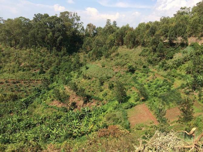
Figure 1. An example of successful landscape level intervention in Burundi