Actualités
Cette section présente des articles et des informations sur les activités réalisées par la FAO à l’aide de technologies et de méthodes géospatiales.
20 November 2018

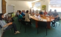
Experts from South Sudan increased their awareness on the land cover database that FAO is preparing and discussed about classification systems adopted suitable for their country adoption thanks to a workshop organized by the FAO Geospatial team in Juba, South...
16 November 2018

FAO’s Geospatial Unit took part in Earth Observation Week, organized by the European Space Agency (ESA). The event focused on Earth Observation (EO) Open Science and Future Earth Observation and took place at the European Space Research Institute in Frascati, Italy. The...
10 September 2018
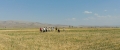
FAO’s Subregional Office for Central Asia led workshops and field trips to the Turkish provinces of Ankara, Konya, Erzurum in July and September 2018 under the project ’Agricultural implications for ecosystem-based adaptation to climate change in Steppe ecosystems’....
29 May 2018
The Republic of Turkey’s Ministry of Food, Agriculture and Livestock (MFAL) is working on a detailed action plan to implement and monitor Ecosystem-Based Adaptation (EBA) in the Anatolian Steppe following April’s ‘study tour’ workshop at FAO Headquarters.
The...
02 April 2018

Last month’s workshop on Regional Land Cover Monitoring in Bangkok saw a strong coordinated effort among participating countries from the Hindu Kush-Himalayan region, to use the same land cover classification systems and produce regionally standardized land cover maps....