Publications
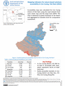
Mapping indicators for nature-based solutions accessibility in Thanh Chuong, Vietnam (2022)
10 October 2022
10 October 2022
Accessibility map was calculated for ThanhChuong district of Viet Nam using the roadnetwork from Open Street Map and the slope fromSRTM. The result was obtained at the spatial resolution of 30 meters and aggregated at...
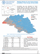
Mapping indicators for nature-based solutions accessibility in Con Cuong, Vietnam (2022)
10 October 2022
10 October 2022
Accessibility map was calculated for Con Cuongdistrict of Viet Nam using the road network fromopen street map and the slope from SRTM. Thedata is obtained at spatial resolution of 30 metersand aggregated at townlets level...

Mapping indicators for nature-based solutions tree cover change in Thanh Chuong, Vietnam (2001-2020)
10 October 2022
10 October 2022
Tree cover change was obtained from global forest cover change1 to assess the gain and loss of treesin Thanh Chuong district of Viet Nam. Theassessment was done from 2001 to 2020 at aspatial resolution of...
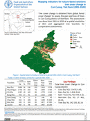
Mapping indicators for nature-based solutions tree cover change in Con Cuong, Vietnam (2001-2020)
10 October 2022
10 October 2022
Tree cover change is obtained from global forest cover change1 to assess the gain and loss of treesin Con Cuong district of Viet Nam. The assessment was done from 2001 to 2020 at a spatial...
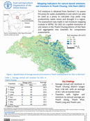
Mapping indicators for nature-based solutions soil moisture in Thanh Chuong, Vietnam (2021)
10 October 2022
10 October 2022
Soil moisture is obtained from Sentinel 1 to assessthe proxy for water availability in soil; which can alsobe used as a proxy to calculate crop yield, cropproductivity, water stress and drought in a region. The...