Publications
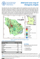
2018 Land Cover Map of Chongoroi, Angola
08 October 2022
08 October 2022
The 2018 land cover map of Chongoroi, Angola has been developed as part of the process of land degradation assessment in the area from 2001 to 2021. A stratified random sampling by land cover...
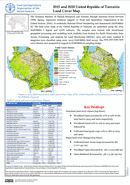
2015 and 2020 Tanzania Land Cover Map
23 September 2022
23 September 2022
The Tanzania Ministry of Natural Resources and Tourism through Tanzania Forest Services (TFS) Agency requested technical support to Food and Agriculture Organization of the United Nations (FAO) to undertake National Forest Monitoring and Assessment...
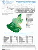
Mapping indicators for nature-based solutions land cover of Con Cuong, Viet Nam (2021)
20 September 2022
20 September 2022
Land cover for Con Cuong district of Viet Nam was prepared for 2021 to assess the performance of nature-based solutions indicators in Viet Nam. Thenational land cover (LC) legends were derived and modified from national...
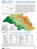
Mapping indicators for nature-based solutions land cover of Thanh Chuong, Vietnam (2021)
16 September 2022
16 September 2022
Land cover for Thanh Chuong district of Viet Nam was prepared for 2021 to assess the performance of nature-based solutions indicators in Viet Nam. The national land cover (LC) legends were derived and modified from...
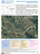
Mapping indicators for nature-based solutions Examples from Viet Nam
12 September 2022
12 September 2022
Geospatial datasets are prepared and mapped to assess and monitor the performance of nature-based solutions (NBS) indicators for Thanh Chuong and ConCuong districts in Viet Nam. The NBS indicators are scalable and applicable to support projects...