ABOUT THE GSASmap
The first ever country-driven Global Map of Salt-affected Soils (GSASmap) V1.0.0 has just been released!
The Global Map of Salt-Affected Soils (GSASmap) is a product containing contributions from over 118 countries with 257, 419 locations containing measured soil data. More than 350 national experts were involved in the harmonization of its input data and methods for mapping salt-affected soils (SAS) and were trained in the state of the art methods for digital soil mapping. Every country then produced their maps following the agreed technical specifications (6). This participatory country-driven process offers more opportunities for future periodic update, which is an important aspect that has been missing in previous global SAS information.
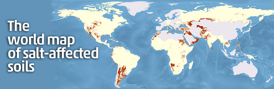
The map represents spatial distribution of SAS information at two depth intervals: 0-30 cm and 30-100 cm including EC, ESP, pH, and classes of salt-affected soils.
The GSASmap represents the spatial distribution of SAS with ECe>2 dS/m, ESP>15% and pH > 8.2 at two depth intervals (0-30 cm and 30-100 cm). With the current information from 118 countries covering 85% of global land area, it shows that more than 424 million hectares of topsoil (0-30 cm) and 833 million hectares of subsoil (30-100 cm) are salt-affected:
- 85% of salt-affected topsoils are saline, 10% are sodic and 5% are saline-sodic
- 62% of salt-affected subsoils are saline, 24% are sodic and 14% are saline-sodic.
These estimates based on the submitted data show that more than 3% of global topsoils and more than 6% of global subsoils are affected by salinity or sodicity. More than two thirds of global SAS are found in arid and semi-arid climatic zones:
- 37% of SAS are located in arid deserts
- 27% of SAS are distributed in arid steppe (half in cold arid steppe and half in hot arid steppe)
Given that this is a country driven process, there are countries who did not prepare their maps because of lack of data, capacities or because they are not affected by SAS. There are two particular regions, EURASIA and Near East and North Africa (NENA) where SAS is an issue, however, they were not able to prepare their maps because of challenges related to data.
How can we use the GSASmap?
- The GSASmap is an important tool for identifying salt-affected soils where sustainable soil management practices shall be adopted to halt salinization and sodification.
- It is a foundation for launching a monitoring framework to track soil salinization and sodification and move into early detection.
- As a knowledge product, the map provides useful information for developing evidence-based decisions for conserving natural salt-affected ecosystems, sustainably manage SAS, and restore areas that had lost their original potential due to salt accumulation.
Related publications
Status of the World's Soil Resources. Main report and Technical summary (EN | ES | FR)