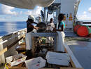
Surveys
The EAF-Nansen Programme survey Timeline highlights the research (carried out by the R/V Dr Fridtjof Nansen. The aim of the Nansen scientific missions is to collect data and information on marine resources, habitats, environment and pollution in the surveyed countries. This knowledge will then help support developing countries in managing better their fisheries at regional and national level.
Navigate the timeline to learn more about the routes and legs of the surveys conducted by the R/V Dr Fridtjof Nansen from 2017 to 2022.
Details from each leg can be accessed by clicking on the Timeline posts, or in the full list below.

Leg 2.2. Mesopelagic Transect
The overall objective of the survey was to study the acoustic properties and biological composition of the mesopelagic community along transect in the oceanic waters between Mauritius and Sri Lanka.
Number of participants
Local participants: 7 (2 women)
Participants from Norway: 7
International participants: 1
Specific objectives:
- Explore the distribution of mesopelagic fish vertically and horizontally from the higher-oxygen regions of the southern Indian Ocean to the low-oxygen regions of the northern Indian Ocean;
- Explore how the biogeochemical water properties are influencing distribution of mesopelagic fish;
- Observe long-term changes in biogeochemistry since WOCE observations from 1995
Leg 2. Indian Ocean (Joint Management Area and Nazareth Bank)
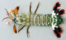
This survey included two legs 2.1-2.2. The first leg of the research was focused on studying the Mascarene Plateau (Joint Management Area, Indian Ocean) - the geomorphology, benthic habitats and benthos, map the occurrence of fish and crustacean resources. The research team also looked into the oceanographic conditions, and recorded the occurrence of micro plastics and marine debris.
The second leg was carried out to explore the distribution of mesopelagic fish vertically and horizontally, from the higher-oxygen regions of the southern Indian Ocean to the low-oxygen regions of the northern Indian Ocean, between Mauritius and Sri Lanka. This survey studied the effect of the biogeochemical water properties on the distribution of mesopelagic fish, and monitored long-term changes in biogeochemistry since WOCE observations from 1995.
- Leg 2.1. Mascarene Plateau and Nazareth Bank
Period: 4 May – 3 June (30 days)
Survey Type: Bottom Habitats Survey
Port of departure: Victoria (Seychelles)
Port of arrival: Port Louis (Mauritius)
Local participants: 19 (8 women)
Participants from Norway: 9
International participants: 1
The main objectives of this leg were to:
- Study the geomorphology, benthic habitats and benthos (multibeam mapping in subareas and along pre-determined transects, habitat and benthos studies emphasising sandy subareas and subareas with macroalgae, seagrass, and coral;
- Map occurrence of fish and crustacean resources;
- Study the oceanographic conditions;
- Record the occurrence of microplastics and marine debris.
- Leg 2.2. Mesopelagic transect
Period: 5 June – 21 June (16 days)
Survey Type: Mesopelagic transect
Port of departure: Port Louis (Mauritius)
Port of arrival: Colombo (Sri Lanka)
Local participants: 7 (2 women)
Participants from Norway: 7
International participants: 1
The overall objective of the survey was to study the acoustic properties and biological composition of the mesopelagic community along transect in the oceanic waters between Mauritius and Sri Lanka.
Specific objectives:
- Explore the distribution of mesopelagic fish vertically and horizontally from the higher-oxygen regions of the southern Indian Ocean to the low-oxygen regions of the northern Indian Ocean;
- Explore how the biogeochemical water properties are influencing distribution of mesopelagic fish;
- Observe long-term changes in biogeochemistry since WOCE observations from 1995.

Leg 1.5. Mesopelagic Transect
The overall objective of the survey was to study the acoustic properties and biological composition of the mesopelagic community in oceanic waters, between Tanzania and the Seychelles.
Number of participants
Local participants: 13 (1 woman)
Norwegian participants: 10
International participants: 2
Specific objectives:
- Map the circulation structure, including meso-scale eddies, in the westernmost part of the Indian Eastern Equatorial Current;
- Map plankton distribution related to the meso-scale eddy structure;
- Map the abundance, distribution and diversity of mesopelagic fish;
- Collect samples for food safety and nutrition.
Leg 1.3. Environmental Monitoring (oil/gas)
The overall objective of this survey was to collect data that will contribute to setting up an environmental baseline for marine habitats, marine biodiversity and the levels of pollutants in the Cabo Delgado Province, Northern Mozambique.
Number of participants
Local participants: 17 (8 women)
Participants from Norway: 11
International participants: 0
Specific objectives:
- Collect samples to determine benthic Biodiversity;
- Collect sediment samples for sediment chemistry and geochemistry;
- Carry out habitat observations (Video and still-photo documentation, Real time identification- Video logger, VAMs) ;
- Collect data on bathymetry (Multibeam Echosounder, Sub bottom profiler);
- Collect samples of marine fish and invertebrates for food safety.