AQUASTAT - FAO's Global Information System on Water and Agriculture
Liberia
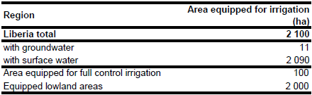
Area equipped for irrigation is 2 100 ha with the majority (2 000 ha) in equipped wetlands [LR01]. The figures refer to year 1987. No up-to-date information or sub-national information on irrigated areas in Liberia is available. The irrigated area estimated that way is visible in the table below and also can be downloaded as Liberia irrigation areas in PDF or Liberia irrigation areas in Excel.
Irrigated area was assigned to areas which were classified as "Mosaic forest / cropland" in the GLC2000 land cover dataset for Africa [LR02] and which additionally were located within three zones marked as irrigated on the FAO irrigation map for Africa [LR03].
Based on the qualitative information contained in the AQUASTAT country reports [LR01] and groundwater use in neighbouring country Guinea, percentage of irrigation area from groundwater was estimated at 0.5 percent.
References
[LR01]: FAO. 2005. AQUASTAT country profile Liberia, FAO, Rome, Italy.
[LR02]: Mayaux, P., Bartholomé, E., Cabral, A., Cherlet, M., Defourny, P., Di Gregorio, A., Diallo, O., Massart, M., Nonguierma, A., Pekel, J.-F., Pretorius, C., Vancutsem, C., and Vasconcelos, M. 2003. The Land Cover Map for Africa in the Year 2000. European Commision Joint Research Centre, available at: http://www-gem.jrc.it/glc2000).
[LR03]: FAO. 1987 (updated in 2005). Irrigated areas in Africa. FAO, Rome, Italy.


