Noticias
En esta sección se presentan artículos y noticias sobre las actividades que lleva a cabo la FAO con apoyo de tecnología y métodos geoespaciales.
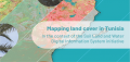
A new report has unveiled a detailed land cover map of Tunisia, highlighting key agricultural areas such as cultivated land, olive trees, date palms, and orchards, while also integrating land water management practices. Using Sentinel-2 satellite imagery and existing water...

The "AgroAdapt: Cultivate the Future" simulation game was showcased at the FAO headquarters at the FAO Innovation booth at the ERC34 exhibition. This game addresses climate change challenges in agriculture, using real data from the FAO's Global Agro-Ecological Zoning System...
.jpg)
The Food and Agriculture Organization of the United Nations (FAO) is committed to supporting countries and communities in building resilience against natural hazards and human-made crises. With the launch of its publication, "Geospatial Applications in Emergency Impact Assessment”, the event,...
26 April 2024
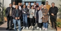
The National Consultative Workshop on the outcomes of the Soil Land and Water Information System (SoLaWISe) initiative was organized by the Food and Agriculture Organization of the United Nations in Tunis from April 22nd to 26th, 2024. A total of...
In a significant step towards achieving a land degradation-neutral world, the Food and Agriculture Organization of the United Nations (FAO) has introduced a cutting-edge online module on the SEPAL platform. This initiative is part of the broader UN Decade on...