Resources

Mid-report on the project
09 December 2019
09 December 2019
Due to more and more frequent extreme climate events (floods, drought, and frosts) and due to the changes in precipitation (amounts, seasonality, intensity) and warming temperatures that are impacting rainfed agriculture and...
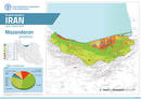
Mazandaran Province - Land cover map
21 November 2019
21 November 2019
To implement the project Improved Agriculture Monitoring Systems through Satellite Imagery for Iran, three parts of the country were selected as pilot areas: Zanjan and Mazandaran provinces, and south Kerman region....

Zanjan Province - Land cover map
21 November 2019
21 November 2019
To implement the project Improved Agriculture Monitoring Systems through Satellite Imagery for Iran, three parts of the country were selected as pilot areas: Zanjan and Mazandaran provinces, and south Kerman region....
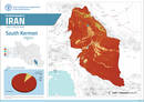
South Kerman region - Land cover map
21 November 2019
21 November 2019
To implement the project Improved Agriculture Monitoring Systems through Satellite Imagery for Iran, three parts of the country were selected as pilot areas: Zanjan and Mazandaran provinces, and south Kerman region....
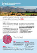
Flyer Project TCP/IRA/3602
24 April 2017
24 April 2017
The flyer describes in a general way what FAO is doing in IRAN, and in a detailed way the impact, goal, outcomes, objectives, methodology, outputs and participants of the project.