
Crop Scenarios
Component 2 / LONG TERM
At the national level, climate change is impacting the crop production and the food security. The project will enable policy and decision makers to access detailed future prevision of crop distribution and productivity as well as socio-economical acceptability of farming and cropping systems that will results due to the impact of climate change (for example, in 100 years’ time).
ສະຖານະການປູກຝັງ
ອົງປະກອບ2 / ໄລຍະຍາວ
ລະດັບຊາດ, ການປ່ຽນແປງດີນຟ້າອາກາດມີຜົນກະທົບຕໍ່ການຜະລິດພືດ ແລະ ການຄ້ຳປະກັນສະບຽງອາຫານ. ໂຄງການດັ່ງກ່າວຈະຊ່ວຍໃຫ້ນະໂຍບາຍ ແລະ ຜູ້ຕັດສີນໃຈສາມາດເຂົ້າເຖີງການກະແຈກກະຈາຍພັນພືດ ແລະ ຜົນຜະລິດໄດ້ໃນອານາຄົດລວມເຖີງການຍອມຮັບໃນລະບົບເສດຖະກິດສັງຄົມຂອງການກະສິກຳ ແລະ ລະບົບການປູກພືດທີ່ຈະສົງຜົນເນື່ອງຈາກຜົນກະທົບຂອງການປ່ຽນແປງດີນຟ້າອາກາດ. (ຕົວຢ່າງໃນ 100 ປີ).ຕົວແບບ ແລະ ເຄື່ອງມືອຸປະກອນການຕັດສີນໃຈອະນຸຍາດການສຳຫຼວດຂອງດີນຟ້າອາກາດ ແລະ ສະພາບທາງດ້ານສັງຄົມກະສິກຳທີ່ສາມາດນຳໃຊ້ເພື່ອແຈ້ງນະໂຍບາຍ ແລະ ວາງແຜນ ແລະ ປະເມີນຜົນໄດ້ຜົນເສຍລະຫວ່າງຄວາມແຕກຕ່າງຍຸດທະສາດການປັບຕົວການຜະລິດກະສິກຳ.ອົງປະກອບນີ້ໄດ້ຈັດຕັ້ງປະຕິບັດໂດຍກົມຄຸ້ມຄອງທີ່ດີນກະສິກຳ (DALaM) ຂອງກະຊສງກະສິກຳ ແລະ ປ່າໄມ້ (MAF).
ຄູ່ຮ່ວມຫຼັກ
- ສະຖາບັນຄົ້ນຄວ້ານະໂຍບາຍສະບຽງອາຫານສາກົນ (IFRRI)
- ອົງກອນແມ່ນ້ຳຂອງ (MRC)
- ສູນສຳລັບການພັດທະນາ ແລະ ສີ່ງແວດລ້ອມ (CDE ມະຫາໄລແຫ່ງຊາດ Bern)
- ອົງການອາຫານໂລກ
- ເພີ່ມປູກຈິດສຳນືກ
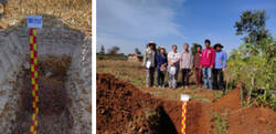
- Two soil profiles in Saravan Province
Data collection process
A national level process is ongoing to collect data from multiple government entities. All government entities working in natural resources data are being invited to a national level event and the collection of data is ongoing. Every government entity is signing a “data sharing agreement” in which the permissions of use the data are detailed.
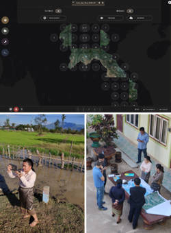
- Field visit for land cover samples' collection
Also, Land Utilization Type is being collected in collaboration with the District Office of Agriculture and Forestry (DAFO). The first consultation meeting on developing was held on July 2018 in Saravan province and the process will be finalized soon.
The update of the existing national soil map will be based on the World Soil Classification Systems is under preparation by the end of 2019. So far, more than 70 soil profiles have been opened and the map should be ready by September 2019.
Cropland cover mapping is ongoing using machine learning. Filtered composition and mosaicking is run using the SEPAL, a cloud computing based platform for autonomous land monitoring, using remotely-sensing data.
The cropland cover map is developed using the ESA Sentinel 2A sensor and classified using the Land Cover Classification System (LCCS), the ISO Standard (ISO 1-19144) classification system developed by FAO and UNEP.
Agro-Ecological Zoning (AEZ) and socio-agricultural scenarios
A spatial analysis system quantifying land productivity based on the FAO AEZ methodology in different time horizons will be undertaken during 2020. The risk scenario will be calculated for the climate change impact in agro-ecological and at the socio-agricultural level.

- AEZ scheme (click to enlarge)
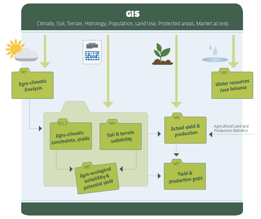
These models and decision-support tools allows exploration of climate and agricultural and socio-agricultural scenarios that can be used to inform policies and planning and assess trade-offs between different agricultural production adaptation strategies.
The component is implemented by Department of Agricultural Land Management (DALaM) of the Ministry of Agriculture and Forest (MAF).
A leaflet describing the activities of component 2 is available here.
Main Outputs:
- A Land Resources Information Management System (LRIMS)
- Calculate a land suitability assessment customized applications and geospatial database (National-AEZ)
- Assess adaptive management strategies relevant for production systems including impact scenarios of water availability, crop yield and socio-economics for all major agro-ecological zones).
- Assessed scenarios will improve policy formulation and planning, and will be integrated climate change scenarios into national agriculture policies, plans and programmes data.