AQUASTAT - FAO's Global Information System on Water and Agriculture
Irrigation and drainage
Thematic discussion
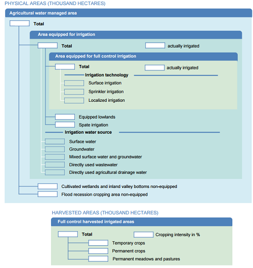
AQUASTAT has adopted the following irrigation typology:
- Area equipped for irrigation: area equipped for full control irrigation + equipped lowlands area + spate irrigation area
- Agricultural water managed area: area equipped for irrigation + cultivated non-equipped lowlands area + cultivated non-equipped flood recession area
Full control irrigation technologies are: surface irrigation, sprinkler irrigation and localized irrigation.
Sources of water used for irrigation are: primary and secondary surface water, primary and secondary groundwater (renewable and fossil), mixed primary and secondary surface water and groundwater, directly used wastewater (treated or not-treated), directly used agricultural drainage water, and in a few exceptional case desalinated water. Secondary water refers to water that was previously withdrawn for agricultural, municipal and industrial purposes and then returned to the system.
The above classifications according to typology, technology and source of water are schematically presented in the following diagram or irrigation area sheet:
Irrigation areas sheets filled in for each country are available from the dropdown menu under "Information sheet" at the top of this page. These sheets are automatically generated from the Main Database and thus always contain the latest information available in the database. Definitions of all terms can be found in the glossary.
Data for the variable "Area equipped for irrigation" is collected by and available in both AQUASTAT and FAOSTAT and harmonization between AQUASTAT and FAOSTAT takes place on a regular basis to ensure consistency between the two.
In AQUASTAT, the irrigation area variables related to source of water refer to the "Area equipped for irrigation". The global map of irrigation areas, which includes sub-national data as well as areas by source of water, also refers to the area equipped for irrigation and that part of the area equipped for irrigation that is actually irrigated.
However, the harvested irrigated crops area and irrigated crop calendars refer to the "Area equipped for full control irrigation" (see also the above Irrigation Areas sheet) and, if information is available, to the part of the area equipped for full control that is actually irrigated. The reason is that most of the time spate irrigation areas and equipped lowlands have irrigated crops just once a year, while the aim of "full control" irrigation is to be able to have two (or three even in a few cases) crops on the same area in a year thanks to irrigation and thus increasing the cropping intensity, which is the harvested crop area divided by the physical irrigated area. Adding spate irrigation and equipped lowlands would reduce the irrigated cropping intensity and therefore not correctly show the possible merits of irrigation.
A special effort is being made to collect quantitative and qualitative information on women in irrigated agriculture. If information is available a special sub-section on "Women and irrigation" is created in the section "Irrigation and drainage development" of the country profile.
Selected publications
A list of all publications is available on the Publications page. A non-exhaustive selection of some publications more specifically related to irrigation is given below:
- Irrigated areas - Atlas of African agriculture research & development
- The role of women in agricultural water management - Results of a pilot project to develop gender-sensitive indicators (in French)
- Update of the Digital Global Map of Irrigation Areas (GMIA) to Version 5
- Groundwater use for irrigation - a global inventory
- The resource outlook to 2050: By how much do land, water and crop yields need to increase by 2050?
- Irrigation Manual - Planning, development, monitoring and evaluation of irrigated agriculture with farmer participation
- Irrigation potential in Africa - A basin approach
- Assessment of irrigation potential in Africa - Arc-Info: a tool for the computation of the irrigation water requirements at continental level


