AQUASTAT - FAO's Global Information System on Water and Agriculture
Republic of Korea
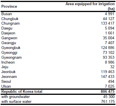
Area equipped for irrigation in the Republic of Korea declined from 888 800 ha in year 1996 [KR01] to 880 365 ha in year 2002 and 806 475 ha in year 2009 [KR02]. Area equipped for irrigation per province was derived from the statistical yearbook 2010 [KR02]. The figures refer to irrigated paddy lands in the year 2009 cropping season. In addition, 203 812 ha of paddy lands are classified in the same inventory as "partially irrigated" [KR02]. The irrigated area per province estimated that way is visible in the table below and also can be downloaded as Republic of Korea irrigation areas in PDF or Republic of Korea irrigation areas in Excel.
The outlines of paddy areas were digitized from a land-use map provided by the Perry-Castañeda Library of the University of Texas [KR03]. Because this map dates back to the year 1973, the shape of the single paddy areas was then adjusted using Landsat satellite imagery [KR04].
In 1996, out of a total irrigated area of 888 800 ha the area served by surface water was an estimated 843 500 ha (95 percent) of which 65 percent was fed by 18 000 reservoirs, 21 percent by 6 000 pumping stations, and 14 percent by 18 000 headworks. The area served by groundwater accounted for 45 300 ha [KR01]. It was assumed, that area equipped for irrigation with groundwater remained constant at 45 300 ha while area equipped for irrigation with surface water declined to 761 175 ha. Area actually irrigated was assumed to be similar to area equipped for irrigation.
References
[KR01]: FAO. 2013. AQUASTAT country profile of the Republic of Korea, version 2010. FAO, Rome, Italy.
[KR02]: Ministry for Food, Agriculture, Forestry and Fisheries. 2010. Food, Agriculture, Forestry and Fisheries Statistical Yearbook 2010. http://www.mifaff.go.kr, 14/03/2011.
[KR03]: Unknown. 1973. Korea (South) - vegetation and land utilization. http://www.lib.utexas.edu/ maps/korea.html, 05/02/2013.
[KR04]: Earth Satellite Corporation. 2004. Landsat GeoCover (2000/ETM+) Edition Mosaics, tiles 071-477 and 071-478. Sioux Falls, USA, USGS, http://glcfapp.umiacs.umd.edu:8080.


