News
Land use in agriculture by the numbers

The source article for this piece can be found on the FAO Statistics Division website.
Land – a notion which broadly includes climate, topography, vegetation, soils and other natural resources – is the basis for agriculture, and the interaction between these components is vital for determining the productivity and sustainability of agro-ecosystems. Especially in the face of climate change and variability, selecting the right land uses for given biophysical and socio-economic conditions is essential for minimizing land degradation, rehabilitating degraded land, ensuring the sustainable use of land resources, and maximizing resilience.
Cropland is land used for the cultivation of crops, both temporary (annuals) and permanent (perennials), and may include areas periodically left fallow or used as temporary pasture. Permanent meadows and pastures are land used for livestock grazing. They include both managed and natural pastures, as well as a range of land cover types used for rangelands, such as grassy and woody savannahs.
Land conversion from natural ecosystems to agriculture has historically been the largest cause of greenhouse gas emissions), linked to loss of biomass and carbon in biomass above and below ground. Today, land conversion to agriculture continues to be a major driver of biodiversity loss and land degradation. Efficient land use and land management plans and strategies are needed to maximize crop productivity while minimizing the potential environmental impact due to excessive loss of habitats and overuse of natural resources such as soils and water.
Global trends
Globally agricultural land area is approximately five billion hectares, or 38 percent of the global land surface. About one-third of this is used as cropland, while the remaining two-thirds consist of meadows and pastures) for grazing livestock.
Within cropland, about 10 percent of the area is used for permanent crops, such as fruit trees, oil palm plantations and cocoa plantations. A further 21 percent is equipped for irrigation, which is an important land management practice in agriculture.
As the global population continues to grow, with the number of people in the world more than doubling between 1961 and 2016, there is greater demand for food. And the strain on land, which is a limited resource, has also grown. Global cropland area per capita decreased continuously over the period between 1961 and 2016: from about 0.45 hectare per capita in 1961 to 0.21 hectare per capita in 2016 (Figure 1, below).
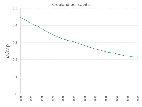
Figure 1. Global cropland per capita, 1961-2016
Regional trends
Regional distribution of agricultural land use is a combination of local agri-climatic edaphic – soil –conditions, and socio-economic drivers. Averaged over the decade between 2007 and 2016, the largest share of agricultural land area was in Asia, accounting for 1.6 global hectares (gha) or 34 percent, followed by the Americas (1.2 gha, or 25 percent) and Africa (1.1 gha, 24 percent), with Europe and Oceania representing each about 9-10 percent of the total.
In terms of irrigation capacity, the region with the largest land area equipped for irrigation over the past decade was by far Asia, with 237 mega hectares (mha), or 70 percent of the world’s total, followed by the Americas (52 mha, or 16 percent), Europe (26 mha, 8 percent), Africa (15 mha, 5 percent) and Oceania (3 mha, 1 percent).
In terms of the relative share of land equipped for irrigation over cropland, Asia also had the largest values (40 percent), followed by the Americas (13 percent), Europe (9 percent), Oceania (7 percent) and Africa (6 percent).
In terms of per capita availability, cropland area per capita between 2007-2016 was smallest in Asia (0.13 hectares per capita), followed by Africa (0.22 hectares per capita), the Americas and Europe (0.40 hectares per capita), and Oceania (1.21 hectares per capita).
Country trends
On average over the last decade, China was the country with the largest agricultural land extent (about 500 million hectares or Mha), followed by the United States, Australia (about 400 Mha each) and Brazil (278 Mha). India had the largest cropland area (nearly 170 Mha), followed by the United States (158 Mha), China and the Russian Federation (about 120 Mha each).
The two countries with the largest irrigated cropland area were India and China, with about 68 Mha each, followed by the United States (27 Mha), Pakistan (20 Mha) and Iran (9 Mha).
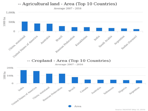
Figure 2. Top ten countries having the largest a) agricultural land area and b) cropland area. Average 2007-2016