AQUASTAT - FAO's Global Information System on Water and Agriculture
Burkina Faso
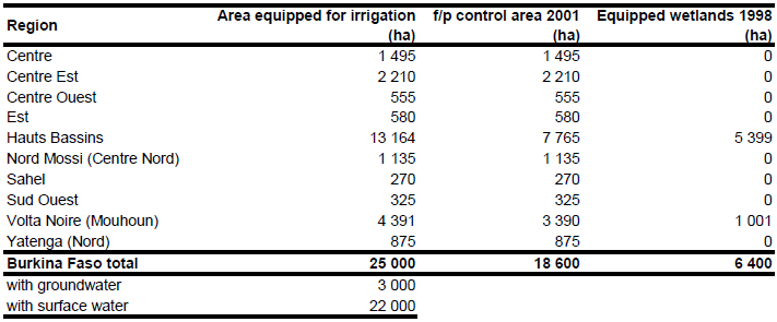
Area equipped for irrigation was reported to be 25 000 ha. Full/partial control area was 18 600 ha in 2001 and equipped wetlands covered 6 400 ha in 1998 [BF01]. Sub-national statistics for full/partial control area summing up to 16 915 ha [BF02]. These statistics refer to year 1996 and obviously underestimate actual irrigated area in region Volta Noire (Mouhoun). The statistics reported for this region an irrigated area of 1 705 ha although there are 3 200 ha in one single project (AMVS-project). Therefore area equipped for irrigation was increased in that region so that the country total is equal to the value reported for 2001 (18 600 ha). Equipped wetlands were assigned to the regions Hauts Bassins and Volta Noire (Mouhoun) based on the statistics derived from the AQUASTAT library for the year 1992. Total area equipped for irrigation per region was then computed as the sum of full/partial control area and equipped wetland area. The irrigated area per region estimated that way is visible in the table below and also can be downloaded as Burkina Faso irrigation areas in PDF or Burkina Faso irrigation areas in Excel.
The location and command area of 23 projects was derived from the FAO-irrigation map for Africa [BF03]. These areas got the highest priority in the distribution process. The command area of the registered schemes added up to 11 535 ha. The second highest priority was given to zones of private irrigation digitized from an irrigation map [BF04] and to areas classified as "irrigated agriculture" in the GLC2000 land cover map of Africa [BF05]. However, the area equipped for irrigation reported by the sub-national statistics was still larger in regions of Yatenga and Sud Ouest than the sum of the corresponding digitized areas. Therefore the remaining irrigated areas was assigned to agricultural land in inland valley bottoms in the larger surrounding of registered irrigation schemes (Yatenga) as digitized from satellite imagery [BF06] or to areas classified as "croplands" or "croplands with open woody vegetation" in the GLC2000 land cover map of Africa (Sud Ouest) [BF05].
Based on the classification of full/partial control schemes and equipped wetlands in the AQUASTAT country profile [BF01] irrigated area from groundwater was estimated being 3 000 ha while area irrigated with surface water was estimated at 22 000 ha. Based on the harvested area of irrigated crops in full/partial control schemes it was assumed that the whole area equipped for irrigation is also actually used for irrigation.
References
[BF01]: FAO. 2005. AQUASTAT country profile Burkina Faso. FAO, Rome, Italy.
[BF02]: Dioma K.S., Douamba T.D., Kambou N.F., Nombre A., Traore T.M. 2003. Stratégie nationale de développement durable de l’irrigation au Burkina Faso (Rapport provisoire). Ministere de l’agriculture, de l’hydraulique, des ressources halieutiques.
[BF03]: FAO. 1987 (updated in 2005). Irrigated areas in Africa. FAO, Rome, Italy.
[BF04]: World Bank. 1998. Pilot private irrigation development project. Project appraisal document. Report No. 18692-BUR (available at http://www-wds.worldbank.org).
[BF05]: Mayaux, P., Bartholomé, E., Cabral, A., Cherlet, M., Defourny, P., Di Gregorio, A., Diallo, O., Massart, M., Nonguierma, A., Pekel, J.-F., Pretorius, C., Vancutsem, C., and Vasconcelos, M. 2003. The Land Cover Map for Africa in the Year 2000. European Commision Joint Research Centre, available at: http://www-gem.jrc.it/glc2000).
[BF06]: Earth Satellite Corporation. 2004. Landsat GeoCover (2000/ETM+) Edition Mosaics, tiles 071-190 and 071-203. Sioux Falls, USA, USGS (available at http://glcfapp.umiacs.umd.edu:8080).


