AQUASTAT - FAO's Global Information System on Water and Agriculture
Belarus
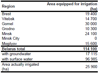
The area equipped for irrigation reached its maximum in the 1980’s at 163 000 ha and declined after to 149 000 ha in 1990, 131 000 ha in 1993 [BY01], 115 100 ha in year 2001 and 114 100 ha in year 2006 [BY02]. Area equipped for irrigation in year 2006 was derived for 6 regions from a statistical yearbook [BY02]. The irrigated area per region estimated that way is visible in the table below and also can be downloaded as Belarus irrigation areas in PDF or Belarus irrigation areas in Excel.
Maps showing the location of irrigation schemes were not available. Since it was reported, that irrigation takes place only in excessively drained areas it was decided to distribute irrigated land to cropland and pastures in lowlands along the major rivers. Additionally irrigated areas were assigned to cultivated land in the Polesye region because it was reported that most of the drainage work was concentrated in that area. Cropland and pasture areas were derived from the GLC2000 data base for Northern Eurasia [BY03]. Cells classified as humid grassland, cropland or cropland / grassland were extracted from this land cover data set if located on river valley bottoms.
Irrigation water is provided mainly by retention tanks. About 77 percent of the area is reported to be irrigated from these reservoirs. Other water sources are canals and groundwater [BY01]. Based on this indicative information percentage of AEI irrigated with groundwater was set to 15 percent (17 250 ha). Because of organizational, economic and technical reasons the irrigation schemes are not operating at full capacity. It can be assumed that the area actually used for irrigation is much lower now compared to the situation in 1990 because irrigation water use declined strongly from 63 Mio m3 in 1985 and 67.3 Mio m3 in 1990 to 5 Mio m3 in 2000 and 11.7 Mio m3 in 2003 [BY04]. Based on the reported ratio of irrigation water extractions in years 1990 and 2003 AAI in year 2003 was estimated at 25 900 ha.
References
[BY01]: FAO. 2012. AQUASTAT country profile of Belarus, version 1997. FAO, Rome, Italy.
[BY02]: National Statistical Committee of the Republic of Belarus. 2011. Environmental protection in the Republic of Belarus. National Statistical Committee of the Republic of Belarus, Minsk, Belarus, 237pp.
[BY03]: Bartalev, S.A., Belward, A.S., Erchov, D.V., Isaev, A.S., Bartholomé, E., Gond, V., Vogt, P., Achard, F., Zubkov, A.M., Mollicone, D., Yu Savin, I., Fritz, S., Repina, G., Hartley, A. 2003. The land cover map for Northern Eurasia for the year 2000. GLC2000 database, European Commision Joint Research Centre, http://www-gem.jrc.it/glc2000.
[BY04]: Ministry of Natural Resources and Environmental Protection. 2003. Environmental conditions in the Republic of Belarus. http://www.nd.minpriroda.by/eng/index.htm, 12/07/2006.


