AQUASTAT - FAO's Global Information System on Water and Agriculture
Belize
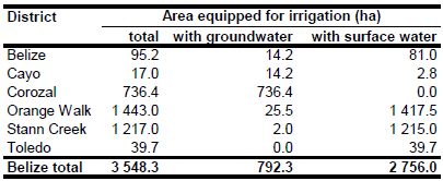
According to the Ministry of Agriculture, area equipped for irrigation was 3 548 ha in year 2005 [BZ01]. The irrigated area per district is visible in the table below and also can be downloaded as Belize irrigation areas in PDF or Belize irrigation areas in Excel.
The irrigated area has been distributed to irrigated rice areas [BZ02] and the remaining irrigated area was equally distributed over area classified as “Agro-productive system” in the Central American Ecosystems Map [BZ03].
Area actually irrigated was assumed to be similar to area equipped for irrigation. Area irrigated with groundwater was 792 ha in year 2005, most of it located in the district Corozal. The remaining area was irrigated by using surface water (rivers) [BZ01].
References
[BZ01]: Ballestero, M., Reyes, V., & Astorga, Y. 2007. Groundwater in Central America: its importance, development and use, with particular reference to its role in irrigated agriculture. In: Giordano, M. & Villholth, K. G., The agricultural groundwater revolution. Opportunities and threads to development. International water Management Institute (IWMI), Colombo, Sri Lanka, 100-128, http://www.iwmi.cgiar.org/Publications/CABI\_Publications/index.aspx, 12/08/2009.
[BZ02]: CIAT. 1997. Distribution of rice in Latin America (1000 ha irrigated rice). http://www.grida.no/ prog/global/cgiar/, 07/04/2001.
[BZ03]: World Bank and CCAD. 2001. Ecosystems of Central America (ArcView regional map files at 1:250,000). World Bank, Comisión Centroamericana de Ambiente y Desarrollo (CCAD), World Institute for Conservation and Environment (WICE), and the Centro Agronómico Tropical de Investigación y Enseñanza (CATIE), Washington, D.C., http://www.birdlist.org/cam/themes/ map_download_page.htm, 15/11/2010.


