AQUASTAT - FAO's Global Information System on Water and Agriculture
Barbados
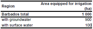
For Barbados no information could be found on irrigated areas on sub-national level. According to the agricultural census in 1989 the total area equipped for irrigation is about 1 000 ha [BB01]. The irrigated area is visible in the table below and also can be downloaded as Barbados irrigation areas in PDF or Barbados irrigation areas in Excel.
The irrigated area was distributed over potential irrigation areas as indicated on a water resources map [BB02]. The map and the related study are available in the AQUASTAT-library.
Irrigation water use is mainly based on the use of 120 private hand-dug wells while use of dams and streams is very limited [BB01]. Based on this qualitative information amount of irrigation area supplied by groundwater was estimated to be 90 percent.
References
[BB01]: FAO. 2000. AQUASTAT country profile of Barbados. FAO, Rome, Italy.
[BB02]: Government of Barbados. 1978. Barbados Water Resources Study - Vol. 4 - Irrigation, map 4.42.


