AQUASTAT - FAO's Global Information System on Water and Agriculture
Brunei Darussalam
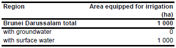
The irrigated area in Brunei Darussalam is reported to be about 1 000 ha [BN01] as shown in the table below and in the downloadable Brunei Darussalam irrigation areas in PDF or Brunei Darussalam irrigation areas in Excel. The figures refer to 1995. No subnational statistics were available.
No map of irrigated areas was available. Therefore, arable land, mainly located in the north of the country, was digitized from satellite imagery [BN02].
Irrigation in Brunei Darussalam is completely based on using surface water sources [BN01].
References
[BN01]: FAO. 2011. AQUASTAT country profile of Brunei Darussalam, version 2010. FAO, Rome, Italy.
[BN02]: Earth Satellite Corporation. 2004. Landsat GeoCover (2000/ETM+) Edition Mosaics, tiles 071-444 and 071-445. Sioux Falls, USA, USGS http://glcfapp.umiacs.umd.edu:8080.


