AQUASTAT - FAO's Global Information System on Water and Agriculture
Democratic Republic of the Congo
Area equipped for irrigation is 10 500 ha [CD01]. The figures refer to year 1995. No sub-national statistics on the extent of irrigated lands have been available.
Irrigated area was assigned to areas in the western part of the country, that were classified as irrigated sugar cane in the AFRICOVER data set [CD02]. These areas are located close to two irrigation projects listed in the FAO irrigation project data base for Africa [CD03]. Additionally, 3 760 ha irrigated area were assigned to projects that are listed in the same database and located near Bumba in the northern part of the country and near the boundaries to Burundi and Rwanda in the eastern part. The irrigated area estimated that way is visible in the table below and also can be downloaded as Democratic Republic of the Congo irrigation areas in PDF or Democratic Republic of the Congo irrigation areas in Excel.
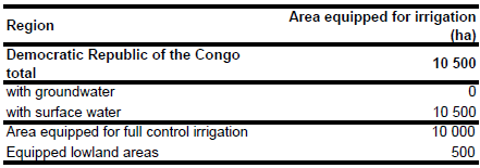
Area actually irrigated was 6 800 ha in year 2000. In year 1995 irrigation was completely based on surface water resources [CD04].
References
[CD01]: FAO. 2004. Suivi du sommet mondial de l’alimentation : 5 ans après - Eléments de stratégie nationale pour la sécurité alimentaire et le développement agricole - Horizon 2015 - République Démocratique du Congo.
[CD02]: FAO. 2005. AFRICOVER, DR Congo - Spatially Aggregated Multipurpose Landcover database. FAO, Rome, Italy, available at http://www.africover.org, 13/12/2004.
[CD03]: FAO. 1987 (updated in 2005). Irrigated areas in Africa. FAO, Rome, Italy.
[CD04]: FAO. 2005. AQUASTAT country profile Democratic Republic of the Congo, FAO, Rome, Italy.


