AQUASTAT - FAO's Global Information System on Water and Agriculture
Algeria
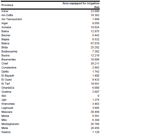
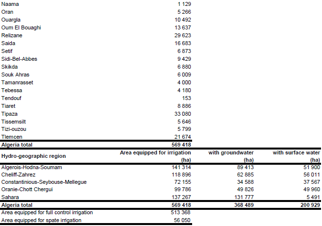
Area equipped for irrigation is 569 418 ha [DZ01]. The figure refers to year 2001. Area equipped for irrigation by province was computed by summing up irrigated areas in large schemes, irrigated area in small schemes and spate irrigation. The position and extent of the large irrigation schemes was derived from two maps [DZ02], while the command area of these schemes in year 1999 stems from another report [DZ03]. The total irrigated area assigned that way to the provinces summed up to 171 550 ha. 56 050 ha of spate irrigation area [DZ01] were assigned to the provinces covering the Saharan Atlas mountains. About 33 000 ha of irrigated areas, of which about 11 000 ha are center pivot systems were digitized from satellite imagery and assigned to the xeric provinces of Adrar, GhardaSa and Tamanrasset. The remaining 308 818 ha of irrigated area were assumed to represent small scale irrigation schemes and assigned to the other provinces relative to statistics stored in the AQUASTAT database. These statistics per province refer to the situation in 1987 and summing up to 221 635 ha. Irrigated area per province estimated that way is visible in the table below and also can be downloaded as Algeria irrigation areas in PDF or Algeria irrigation areas in Excel.
The shape of the boundaries of the 20 large irrigation schemes as digitized from two maps [DZ02] was adjusted by using satellite imagery [DZ04]. The positions of 77 small scale schemes (<500 ha) and 38 medium scale schemes (500 - 1 000 ha) were digitized from the same two maps [DZ02]. 250 ha irrigated area was assigned to each small scale scheme and 750 ha to each medium scale scheme respectively. Thus, the total irrigated area assigned to known irrigation schemes adds up to 219 300 ha. The remaining part of irrigated area was spread over cultivated land as digitized from satellite imagery [DZ04].
Area equipped for irrigation with groundwater for each of the five hydro geographic regions of Algeria was computed based on the reported percentages of groundwater use in full/partial control irrigation areas in these regions [DZ05] and was 368 489 ha (64.7 percent of total area equipped for irrigation) in total. Area actually irrigated in year 2001 was 453 300 ha (79.6 percent of area equipped for irrigation) [DZ01].
References
[DZ01]: FAO. 2005. AQUASTAT country profile Algeria. FAO, Rome, Italy.
[DZ02]: Côte, M. 1993. L'irrigation en Algerie. Commentaire de la carte au 1/1,000,000. In H. Popp & K. Rother, eds. Die Bewässerungsgebiete im Mittelmeerraum, pp. 161-164. Passau, Germany, Passavia Universitätsverlag.
[DZ03]: République algérienne démocratique et populaire, Conseil national économique et social, Commission sur les perspectives de développement économique et social. 1999. Problématique de développement agricole: Éléments pour un débat national.
[DZ04]: Earth Satellite Corporation. 2004. Landsat GeoCover (2000/ETM+) Edition Mosaics, tiles 071-181, 071-192, 071-193, 071-194, 071-195, 071-204, 071-205, 071-206, 071-207, 071-208, 071-216, 071-217, 071-218, 071-219 and 071-220. Sioux Falls, USA, USGS (available at http://glcfapp.umiacs.umd.edu:8080).
[DZ05]: FAO. 2008. Etude sur la gestion des eaux souterraines dans des pays pilotes du Proche-Orient. Rapport Algerie. Bureau régional de la FAO pour le Proche-Orient, Cairo, Egypt.


