AQUASTAT - FAO's Global Information System on Water and Agriculture
Egypt
Area equipped for irrigation is reported to be 3 422 178 ha [EG01]. The figures refer to year 2002.
Irrigated area was distributed within the districts by using AFRICOVER data on land cover [EG02]. First irrigated area was assigned to polygons classified as completely covered by irrigated crops and in a second step (if necessary) to polygons classified as mixture between irrigated crops and other land cover. However, in some districts the area reported as irrigated by the statistics was still larger than the total area of polygons classified by AFRICOVER as irrigated or partly irrigated. Therefore for the districts of Port Said, Cairo, Ismailia, Suez, Fayoum and Gharbia the difference was assigned to areas adjacent to irrigated areas and classified as bare soil. The irrigated area per governorate estimated that way is visible in the table below and also can be downloaded as Egypt irrigation areas in PDF or Egypt irrigation areas in Excel.
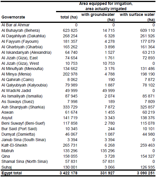
All the area equipped for irrigation was used for irrigation in year 2002. In year 2000 about 11 percent of the irrigated area of the country (361 176 ha) was irrigated from groundwater and 217 527 ha from mixed water while the remaining 2 843 475 ha were irrigated from surface water [EG03]. Groundwater extraction is concentrated in desert oases, on the Sinai peninsula and the New Valley [EG03] and therefore in the related provinces of Matruh, Al Wadi al Jadid, Al Jizah, Janub Sina and Shamal Sina. Total irrigated area in these provinces was 331 927 ha. The province Al Jizah was split in a western part representing oases agriculture and an eastern part representing irrigation using water from the Nile River. It was assumed that irrigation in the provinces mentioned before (except the eastern part of Al Jizah) was from groundwater. The remaining groundwater irrigation area, the area irrigated from mixed water and the irrigation area from surface water was assigned to the remaining part of the country representing mainly the use of River Nile water, reused drainage water and treated waste water.
References
[EG01]: Ministry of Agriculture and Land Reclamation. 2003. Agricultural statistics, Volume 2, summer and Nili crops 2002. Sector of Economic Affairs. Arab Republic of Egypt.
[EG02]: FAO. 2005. AFRICOVER, Egypt - Spatially Aggregated Multipurpose Landcover database, FAO, Rome, Italy, http://www.africover.org, 13/12/2004.
[EG03]: FAO. 2005. AQUASTAT country profile Egypt, FAO, Rome, Italy.


