AQUASTAT - FAO's Global Information System on Water and Agriculture
Guinea Bissau
Area equipped for irrigation is 8 562 ha in full/partial control schemes, 13 996 ha in equipped wetlands and thus 22 558 ha in total [GW01]. The figures refer to year 1996. No sub-national statistics on the extent of irrigated lands have been available. The irrigated area estimated that way is visible in the table below and also can be downloaded as Guinea Bissau irrigation areas in PDF or Guinea Bissau irrigation areas in Excel.
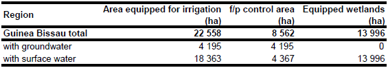
202.5 ha of irrigated area was first assigned to three known projects (Carantabà, Contubuol and Bafatà) as mentioned in the country profile [GW01]. The remaining fraction of full/partial control area (8 449.5 ha) was assigned to areas along the Geba river [GW01] as digitized from satellite imagery [GW02]. The 13 996 ha of irrigated area reported to be in mangroves [GW01] was assigned to land locked areas classified as "Mangrove" or "Irrigated cropland" in the GLC2000 land cover dataset for Africa [GW03].
Area actually irrigated was similar to area equipped for irrigation in year 1996. 6 percent of the 8 562 ha in full/partial control schemes are irrigated with groundwater, 8 percent with surface water and the remaining 86 percent with a mixture of water from both sources [GW01]. By assuming a contribution of 50 percent groundwater in water from mixed sources area equipped for irrigation with groundwater was computed as 4 195 ha.
References
[GW01]: FAO. 2005. AQUASTAT country profile Guinea Bissau, FAO, Rome, http://www.fao.org/ ag/agl/aglw/AQUASTAT/countries/index.stm, 28/02/2006.
[GW02]: Earth Satellite Corporation. 2004. Landsat GeoCover (2000/ETM+) Edition Mosaics, tile 071-166. Sioux Falls, USA, USGS (available at http://glcfapp.umiacs.umd.edu:8080/esdi/index.jsp).
[GW03]: Mayaux, P., Bartholomé, E., Cabral, A., Cherlet, M., Defourny, P., Di Gregorio, A., Diallo, O., Massart, M., Nonguierma, A., Pekel, J.-F., Pretorius, C., Vancutsem, C., and Vasconcelos, M. 2003. The Land Cover Map for Africa in the Year 2000. European Commision Joint Research Centre, available at: http://www-gem.jrc.it/glc2000).


