AQUASTAT - FAO's Global Information System on Water and Agriculture
Honduras
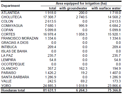
The total area equipped for irrigation in Honduras increased from 73 210 ha [HN01] in year 1997 to 81 631 ha in year 2005 [HN02]. To assign area equipped for irrigation to departments, data were used from the General Department of Irrigation and Drainage as cited in [HN02]. The irrigated area per department is visible in the table below and also can be downloaded as Honduras irrigation areas in PDF or Honduras irrigation areas in Excel.
The irrigated area within the provinces was distributed using several irrigation maps which were published between 1970 and 1992 [HN03], [HN04], [HN05], [HN06]. The remaining area equipped for irrigation was equally distributed over area classified as “Agro-productive system” in the Central American Ecosystems Map [HN07].
Area equipped for irrigation with groundwater was 6 264 ha in year 2005 [HN02]. It was assumed that 75 percent of the area equipped for irrigation is actually being used [HN01].
References
[HN01]: FAO. 2000. AQUASTAT country profile of Honduras. FAO, Rome, Italy.
[HN02]: Ballestero, M., Reyes, V., & Astorga, Y. 2007. Groundwater in Central America: its importance, development and use, with particular reference to its role in irrigated agriculture. In: Giordano, M. & Villholth, K. G., The agricultural groundwater revolution. Opportunities and threads to development. International water Management Institute (IWMI), Colombo, Sri Lanka, 100-128, http://www.iwmi.cgiar.org/Publications/CABI\_Publications/index.aspx, 12/08/2009.
[HN03]: AID Resources Inventory Center. ca. 1970. Map Honduras - Drainage. AID Resources Inventory Center, Corps of Engineers, USA. [HN04]: Org. de los Estados Americanos. 1992. Honduras - Proyecto de Manejo de los Recursos Naturales Renovables de la Cuenca del Embalse el Cajon, mapa 10.
[HN05]: Government of the Republic of Honduras. 1978. Feasibility Study on the agricultural Development in the Choluteca River Basin, Vol. 1, p. 96, 106, 177.
[HN06]: World Bank. 1993. Central America - Subsector Study on private Irrigation, Vol. 1, p. 193.
[HN07]: World Bank and CCAD. 2001. Ecosystems of Central America (ArcView regional map files at 1:250,000). World Bank, Comisión Centroamericana de Ambiente y Desarrollo (CCAD), World Institute for Conservation and Environment (WICE), and the Centro Agronómico Tropical de Investigación y Enseñanza (CATIE), Washington, D.C., http://www.birdlist.org/ cam/themes/map_download_page.htm, 15/11/2010.


