AQUASTAT - FAO's Global Information System on Water and Agriculture
Iran (Islamic Republic of)
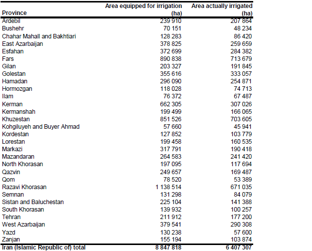
Area equipped for irrigation was 8 131 564 ha in year 2003 [IR01]. However, statistics reported per province were 8 297 031 ha in total for the same year, of which an area of 5 141 157 ha was used for annual crops, 1 282 188 ha for orchards and nurseries and the remaining area was fallow in that year [IR02]. AEI per province for year 2003 was derived from the Statistical Yearbook of Iran [IR02] and increased in 11 out of the 30 provinces to the maximum of the area actually irrigated reported in annual steps for the period 2004/2005 – 2009/2010 [IR03]. Total AEI estimated that way for the whole country was 8 847 818 ha. The irrigated area per province and region is visible in the table below and also can be downloaded as Iran (Islamic Republic of) irrigation areas in PDF or Iran (Islamic Republic of) irrigation areas in Excel.
Irrigated areas were assigned to regions classified as irrigated (priority 8) or as mosaic of irrigated land and other land use (priority 7) in a land cover inventory that is based on Landsat imagery and was developed in year 2006 [IR04]. The distribution of irrigated land in this inventory fitted very well to former maps showing the extent of irrigated land in Iran, e.g. [IR05] and [IR06].
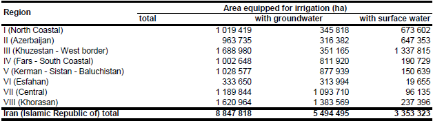
Percentage of irrigation water use from ground- and surface water reported for 8 water regions and year 1995 [IR07]. It was assumed that the ratio between AEI irrigated with groundwater and total AEI was similar to the ratio between irrigation water use from groundwater and total irrigation water use. AEI from groundwater computed that way for the whole country was 56.7 percent of total AEI and scaled to meet the 62.1 percent percentage irrigated area with groundwater supply reported in the AQUASTAT data base for year 2003 [IR01]. Area actually irrigated was 6 423 342 ha in year 2003 [IR02], while total harvested irrigated cropped area was 8 592 554 ha in the same year [IR01]. This indicates that multicropping is practised on a large extent of the land used for irrigated annual crops. Area actually irrigated varied between 5 849 455 ha and 6 739 810 ha in period 2005 – 2010 [IR03]. AAI per province was computed therefore as the mean of the annual AAI reported for the period 2004/2005 – 2009/2010 [IR03]. Total AAI estimated that way for the whole country was 6 407 307 ha.
References
[IR01]: FAO. 2012. AQUASTAT country profile of Iran (Islamic Republic of), version 2008. FAO, Rome, Italy.
[IR02]: Statistical Centre of Iran. 2006. Iran Statistical Yearbook 1385. Statistical Centre of Iran, Tehran, Iran, http://eamar.sci.org.ir/, 19/08/2009.
[IR03]: Ministry of Jihad-e-Agriculture. 2007-2012. Agricultural Statistics of Iran 1384-1388. http://www.maj.ir/portal/Home/Default.aspx?CategoryID=20ad5e49-c727-4bc9-9254-de648a5f4d52, 30/11/2012.
[IR04]: Ministry of Jihad-e-Agriculture. 2006. Landcover characterization of Iran. Data set provided by Noroozi Ali Akbar, Soil Conservation & Watershed Management Research Institute (SCWMRI), Ministry of Jihad-e-Agriculture, Islamic Republic of Iran.
[IR05]: Universität Tübingen. 1993. Tübinger Atlas des Vorderen Orients (TAVO), plate AX3.Wiesbaden, Germany, Reichert.
[IR06]: Universität Tübingen. 1993. Tübinger Atlas des Vorderen Orients (TAVO), plate AX1. Wiesbaden, Germany, Reichert.
[IR07]: Bybordi, M. 2002. Irrigation and water management in Iran. A contribution to a FAO sponsored project: Framework for Sustainable Agricultural Development Strategy in Iran. Tehran, Iran, 43 pp.


