AQUASTAT - FAO's Global Information System on Water and Agriculture
Jamaica
The total area equipped for irrigation in Jamaica was 26 650 ha in year 1997 [JM01] and more recent reports indicate the extent of irrigation schemes has not changed much until year 2009 [JM02], [JM03]. The figures per parish originate from the National Irrigation Development Plan [JM01] and refer to 1997. Most of the irrigated area is concentrated in the southern parish areas.
The irrigated area within the parish areas was distributed using a map showing the outlines of 15 major irrigation schemes in 1997 [JM01]. The remaining irrigated area (mainly located in the northern parishes) was distributed to cropland and plantations extracted from a land use map [JM04]. The irrigated area per parish estimated that way is visible in the table below and also can be downloaded as Jamaica irrigation areas in PDF or Jamaica irrigation areas in Excel.
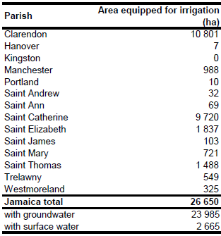
It was estimated that 92 percent of the total water withdrawal in year 1993 was from groundwater and that agriculture accounted for 75 percent of the withdrawals [JM05]. This gives evidence for the importance of groundwater use in irrigation. Based on this information percentage of irrigated areas supplied by groundwater was estimated at 90 percent.
References
[JM01]: Harza Engineering Company International L.P. 1998. Preparation of a National Irrigation Development Plan and preparation of an Irrigation Investment Project. Executive summary. Report available in the AQUASTAT-library.
[JM02]: Planning Institute of Jamaica. 2009. Vision 2030 Jamaica - National Development Plan, final draft Agriculture Sector Plan. http://www.vision2030.gov.jm/SectorPlans/tabid/75/Default.aspx, 14/03/2012.
[JM03]: National Irrigation Commission. 2011. NIDP Irrigated Crop Production Benefits. National Irrigation Commission, http://www.nicjamaica.com/NIDP/NIDP%20-%20Irrigated%20Crop%20 Prod.%20%20Benifits.pdf, 14/03/2012.
[JM04]: Government of Jamaica, Forestry Department. 1998. 1998 Land use / cover of the island of Jamaica. Forestry Department, http://www.forestry.gov.jm/web\_downloads/ LU98_JAD2001.zip, 14/03/2012.
[JM05]: FAO. 2000. AQUASTAT country profile of Jamaica, version 1997. FAO, Rome, Italy.


