AQUASTAT - FAO's Global Information System on Water and Agriculture
Libya
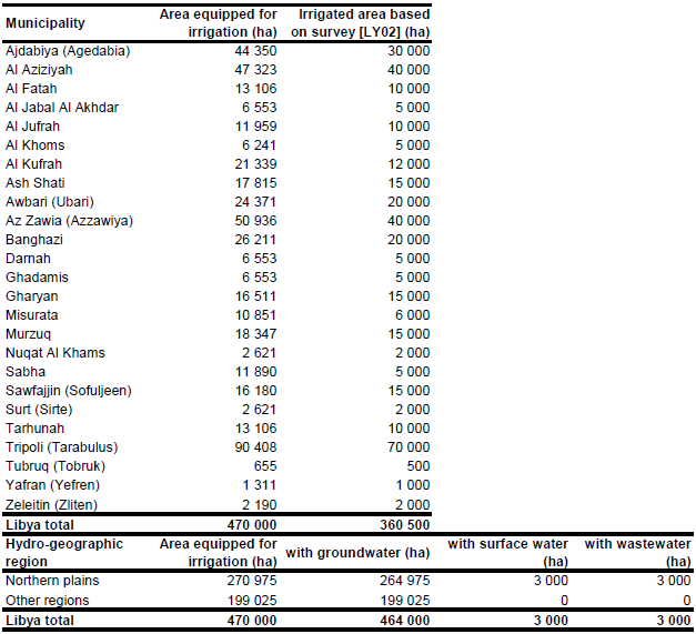
Area equipped for irrigation is reported to be about 470 000 ha, while area actually irrigated was estimated at 316 000 ha [LY01]. The figures refer to year 2000. Irrigation infrastructure that is still functioning was reported for year 1999 by province [LY02]. The total area added up to 360 500 ha. However, it was also stated, that the study may underestimate the real extent of private irrigation, which is dominant in Libya. Therefore, to compute area equipped for irrigation by province, area equipped for irrigation in private schemes was scaled so that the total area equipped for irrigation meets the figures reported for the whole country for year 2000. The irrigated area per municipality estimated that way is visible in the table below and also can be downloaded as Libya irrigation areas in PDF or Libya irrigation areas in Excel.
The position and extent of the public irrigation schemes was digitized from maps published in [LY02]. The command area of these schemes was also given in these report and summed up to about 88 000 ha. Additionally, some irrigated areas were digitized from maps published in [LY03] and from a map belonging to the AQUASTAT country profile [LY01]. These areas were assumed to represent the major areas of private irrigation. The shape of the boundaries of all digitized irrigation areas were improved by using satellite imagery [LY04].
By far the most irrigation schemes are using groundwater. Only 0.65 percent (3 000 ha) of the total area equipped for irrigation is using water from surface water sources and on a similar acreage wastewater is used [LY01]. These areas were assigned to the northern plains while for the rest of the country it was assumed that irrigation is completely from groundwater.
References
[LY01]: FAO. 2006. AQUASTAT country profile Libyan Arab Jamahiriya, FAO, Rome, Italy.
[LY02]: Palas, P., and Salem, O. 2000. Water resources utilisation and management of the Socialist People Arab Jamahiriya. 65 pp. Report available in the AQUASTAT-library.
[LY03]: Schliephake, K. 1993. Libyens Bewässerung und der "Große künstliche Fluß". In H. Popp & K. Rother, eds. Die Bewässerungsgebiete im Mittelmeerraum, pp. 185-192. Passau, Germany, Passavia Universitätsverlag.
[LY04]: Earth Satellite Corporation, 2004. Landsat GeoCover (2000/ETM+) Edition Mosaics, tiles 071-217, 071-218, 071-219, 071-231, 071-232, 071-233, 071-242, 071-243, 071-244 and 071-245. Sioux Falls, USA, USGS (available at http://glcfapp.umiacs.umd.edu:8080/esdi/index.jsp).


