AQUASTAT - FAO's Global Information System on Water and Agriculture
Madagascar
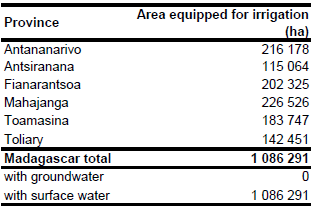
Area equipped for irrigation is 1 086 291 ha [MG01]. The figures refer to year 2000. The disaggregation of the irrigated area to the province level is based on figures reported for the year 1992. The equipped area per province for this year added up to 1 087 000 ha in total and was scaled so that the sum fits to the national value reported for the year 2000. The irrigated area per province estimated that way is visible in the table below and also can be downloaded as Madagascar irrigation areas in PDF or Madagascar irrigation areas in Excel.
The location and command area of 38 irrigation schemes was derived from the FAO irrigation map for Africa [MG02]. The total command area of these schemes was 154 520 ha. 13 polygons representing other irrigation areas where derived from the same map. The location of 158 irrigation projects was derived from another irrigation map [MG03]. The boundaries from 14 other irrigation areas where digitized from a map published in [MG04]. In the next step cultivated areas were digitized from satellite imagery [MG05] if they were located inside the polygons digitized before or around the points representing irrigation projects. Those areas that were marked as irrigated on the irrigation maps and additionally also found to be cultivated got the highest priority in the distribution process. After some irrigation was also distributed to the other areas assumed to represent widespread small scale irrigation.
Area actually irrigated was 1 080 691 ha in year 2000 and completely based on the use of surface water sources [MG01].
References
[MG01]: FAO. 2005. AQUASTAT country profile Madagascar, FAO, Rome, Italy.
[MG02]: FAO. 1987 (updated in 2005). Irrigated areas in Africa. FAO, Rome, Italy.
[MG03]: O.N.E. (unknown). Les perimeters irrigués. Map showing the location of the GPI and PPI projects, available in the AQUASTAT library.
[MG04]: Achtnich, W. 1980. Bewässerungslandbau. Verlag Eugen Ulmer, Stuttgart, Germany.
[MG05]: Earth Satellite Corporation, 2004. Landsat GeoCover (2000/ETM+) Edition Mosaics, tiles 071-714, 071-715, 071-716, 071-717, 071-720, 071-721 and 071-722. Sioux Falls, USA, USGS (available at http://glcfapp.umiacs.umd.edu:8080/esdi/index.jsp).


