AQUASTAT - FAO's Global Information System on Water and Agriculture
Mali
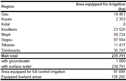
Area equipped for irrigation is 235 791 ha [ML01]. The figures refer to year 2000. Table 4 in the AQUASTAT country profile [ML01] lists the different types of water managed areas per region. However, figures for managed wetlands are not given separately for equipped and non-equipped areas. To estimate total area equipped for irrigation per region it was assumed therefore, that the 60 000 ha of non-equipped wetlands are located in regions of Segou, Mopti and Tombouctou only and that the ratio of equipped versus non-equipped wetlands is the same for all three regions. The irrigated area per region estimated that way is visible in the table below and also can be downloaded as Mali irrigation areas in PDF or Mali irrigation areas in Excel.
The outlines of the irrigated areas of the country were digitized from a irrigation map present in the AQUASTAT library [ML02]. The command area of 6 very large schemes covering 51 635 ha in total was derived from the FAO irrigation map for Africa [ML03]. The shapes of the boundaries of the digitized irrigation areas were improved by using satellite imagery [ML04].
75 percent of the total area equipped for irrigation was actually irrigated in year 2000 while the area equipped for irrigation with groundwater was about 1 000 ha (1 percent of area equipped for irrigation in full/partial control schemes) [ML01].
References
[ML01]: FAO. 2005. AQUASTAT country profile Mali, FAO, Rome, Italy.
[ML02]: Ministere de l'Agriculture de l'Elevage et de la Peche. 2003. Carte d'Irrigation du Mali par Regions Hydrauliques. Direction Nationale de L'Aménagement et de L'Equipement Rural (DNAER). Map available in the AQUASTAT library.
[ML03]: FAO. 1987 (updated in 2005). Irrigated areas in Africa. FAO, Rome, Italy.
[ML04]: Earth Satellite Corporation, 2004. Landsat GeoCover (2000/ETM+) Edition Mosaics, tiles 071-178, 071-179, 071-180, 071-190, 071-191, 071-192, 071-204 and 071-205. Sioux Falls, USA, USGS (available at http://glcfapp.umiacs.umd.edu:8080/esdi/index.jsp).


