AQUASTAT - FAO's Global Information System on Water and Agriculture
Mongolia
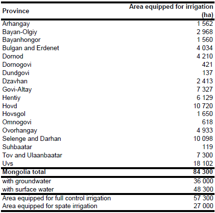
Area equipped for irrigation in year 1993 comprised of 43 400 ha registered schemes using sprinkler irrigation, 13 900 ha of unregistered schemes using surface irrigation methods and 27 000 ha of traditional spate irrigation. However, in 1992 only 52 percent of the sprinkler irrigation area was operational [MN01]. An inventory of the irrigated area per aimag (district) was only available for the sprinkler-irrigation schemes [MN02]. Most of the sprinkler-irrigated area is located in the west and the north of the country. It was also reported that about 80 percent of the surface-irrigation schemes are located in the west of the country [MN03]. Therefore, in order to estimate the total f/p control area equipped for irrigation at aimag level, the sprinkler-irrigated area per aimag was scaled so that the sum of the irrigated areas was 57 300 ha (sum of sprinkler irrigation and full control surface irrigation). The extent of spate irrigation was estimated by computing for each district the difference between the area classified as irrigated cropland in the Globcover landcover classification for Central Asia (MN04) and the AEI under f/p control and by scaling this computed difference using a constant coefficient so that the total area equalled the reported 27 000 ha. The irrigated area per province is visible in the table below and also can be downloaded as Mongolia irrigation areas in PDF or Mongolia irrigation areas in Excel.
The location of 156 sprinkler-irrigation schemes was derived from a recent inventory [MN02]. The total area equipped for irrigation in these schemes was reported as being 43 381 ha. Geographical coordinates of the schemes were missing in the inventory. However, the name of the project and the name of the closest village were given. Therefore, the geographical coordinates of the villages were detected by using the Geographical Names Server of the National Geospatial-Intelligence Agency (available at http://earth-info.nga.mil), and the related irrigated areas were assigned to these locations. However, the location of 13 schemes covering 2 060 ha in total could not be found in this way. In addition, the location of the unregistered schemes (covering about 13 900 ha in total) and the location of the spate irrigation schemes (covering about 27 000 ha in total) was unknown. Therefore, area classified as irrigated cropland was extracted from the Globcover regional land cover product for Central Asia [MN04] and irrigated land in unregistered schemes or spate irrigation was distributed to these areas.
According to a report published more recently [MN05] there were 43 000 ha irrigated area in 1990, of which 16 000 ha (37 percent) were irrigated with surface water. Likely these statistics referred to the registered schemes only. Based on this information it was assumed that 37 percent of the registered and unregistered irrigation schemes and additionally all of the spate irrigation areas are irrigated with surface water resulting in 48 300 ha (57.3 percent) of equipped area irrigated with surface water and 36 000 ha (42.7 percent) irrigated with groundwater. Area actually irrigated was estimated at 62 900 ha [MN01].
References
[MN01]: FAO. 2013. AQUASTAT country profile of Mongolia, version 2011. FAO, Rome, Italy.
[MN02]: FAO. 1994. Irrigation rehabilitation project, Working Paper 1. FAO, Rome, Italy.
[MN03]: FAO. 1995. Irrigation rehabilitation project. Working Paper 3. FAO, Rome, Italy.
[MN04]: ESA. 2008. Regional Globcover Land Cover – Central Asia. Version 2.2. http://postel.mediasfrance.org/en/DOWNLOAD/, 24/03/2009. [MN05]: Tuinhof, A. and Nemer, B. 2009. Groundwater assessment in the Gobi region. Report to the World Bank, prepared by Acacia Water, http://siteresources.worldbank.org/INTMONGOLIA/ Resources/Southern_mongolia_groundwater_assessment_eng.pdf, 24/08/2009.


