AQUASTAT - FAO's Global Information System on Water and Agriculture
Nigeria
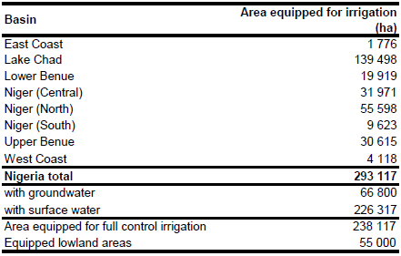
Area equipped for irrigation is 293 117 ha [NG01]. Recently published sub-national statistics were available for the schemes controlled by the River Basin Development Authority (RBDA) only [NG01]. Therefore irrigated area was assigned to river basins according to figures originating from the AQUASTAT-library and refering to 1993. The irrigated area in large and medium scale schemes adds up to 119 350 ha. Areas indicated as "Fadama type irrigation" account for 181 000 ha, which brings the total to 300 350 ha. Irrigated area was scaled so that the country-totals meet the figures as reported for the year 2004. The irrigated area per basin estimated that way is visible in the table below and also can be downloaded as Nigeria irrigation areas in PDF or Nigeria irrigation areas in Excel.
The location and extent of 65 public irrigation schemes was derived from a map and an inventory published in [NG01] and from the FAO irrigation map for Africa [NA02]. The total command area of these schemes was 81 103 ha. The boundaries of the 7 largest schemes (total irrigated area of these schemes was 69 750 ha) were digitized from satellite imagery [NG03]. The remaining irrigated area was assigned to cultivated land in valley bottoms of the large rivers as digitized from satellite imagery. [NG03].
Area actually irrigated was 218 840 ha in year 2004 [NG04]. Irrigation in the public irrigation schemes is predominantly from surface water sources (rivers, lakes, reservoirs). An inventory of 62 public irrigation schemes covering 82 205 ha listed 60 irrigation schemes having surface water supply and two schemes (in total 240 ha) having supply from groundwater [NG01]. In contrast, water supply in the private sector was reported to be mainly from shallow wells or small streams [NG04]. It was assumed, that the percentage of irrigation area supplied from groundwater for public and state farms was similar to the percentage reported in [NG01] while for the private irrigation schemes 50 percent groundwater supply was assumed. Irrigation in the traditional fadama-system was assigned to surface water supply because this system represents wetland cultivation using flood recession water. Although it was reported that farmers in the fadama-system also use wells to extract the water [NG04], most of these structures are not permanent and move from year to year. This procedure resulted in 66 800 ha area equipped for irrigation with groundwater (about 23 percent of total equipped area).
References
[NG01]: Enplan Group. 2004. Review of the Public Irrigation Sector in Nigeria. Draft Final Report of Project UTF/046/NIR/UTF.
[NG02]: FAO. 1987 (updated in 2005). Irrigated areas in Africa. FAO, Rome, Italy.
[NG03]: Earth Satellite Corporation, 2004. Landsat GeoCover (2000/ETM+) Edition Mosaics, tiles 071-201, 071-202, 071-203, 071-213, 071-214, 071-215, 071-228 and 071-229. Sioux Falls, USA, USGS (available at http://glcfapp.umiacs.umd.edu:8080/esdi/index.jsp).
[NG04]: FAO. 2005. AQUASTAT country profile Nigeria, FAO, Rome, Italy.


