AQUASTAT - FAO's Global Information System on Water and Agriculture
Pakistan
Data on the extent of area equipped for irrigation is not collected by statistical surveys in Pakistan. Statistics available from the Central government (e.g. the Agricultural Census Organization) or institutions of the province governments (e.g. the Ministries of agriculture) distinguish the net area under irrigation and the sown area of irrigated crops. The net area under irrigation does not account for structures that were not operating in the year of the survey. It is therefore similar to the definition of area actually irrigated used in this inventory but does not account consistently for spate irrigation. The sown area of irrigated crops is typically higher than the area equipped for irrigation because double cropping is practised in many regions of Pakistan. Area equipped for irrigation reported by FAO-AQUASTAT is therefore based on additional information provided by the FAO country questionnaire. According to this questionnaire total area equipped for irrigation was 19 990 000 ha in year 2008 consisting of 19 270 000 ha full control irrigation and 720 000 ha spate irrigation area while the harvested area of irrigated crops was 21 451 674 ha [PK01]. To estimate area equipped for irrigation, area actually irrigated and area irrigated with groundwater or water extracted from surface water bodies at the district level, data provided by different institutions under the responsibility of the provinces have been used for this inventory. Data availability has been very different resulting in different base years of the statistics used here but if possible, data related to year 2005 were used. The specific references are given below for each federal state. It is necessary to point out that some statistics were no more available for download at the time of the preparation of this report because important parts of the data infrastructure of Pakistan were offline (e.g. the servers of the Sustainable Development Networking Programme that hosted many databases and statistics at the district level). Statistics cited in this report that are no more available for download can be obtained from the authors on request. The irrigated area per district is visible in the table below and also can be downloaded as Pakistan irrigation areas in PDF or Pakistan irrigation areas in Excel.
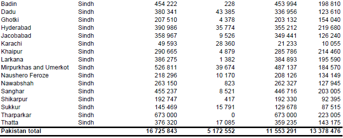
Total area equipped for irrigation estimated using the references and methods described below was 16 725 843 ha of which 5 172 552 ha were irrigated with groundwater and the remaining area with water extracted from surface water bodies. Area actually irrigated was 13 378 476 ha. Total area equipped for irrigation in this inventory is therefore lower than the one reported in the FAO AQUASTAT country report [PK01] but agrees quite well with recent data originating from the agricultural census 2010 [PK02]. According to the census report cultivated area with irrigation facilities is 13 801 088 ha while another 3 184 009 ha are classified as Barani (areas depending on flood or seepage water). The spate irrigation areas belong therefore, together with non-equipped flood recession cropping areas, to the Barani category. Cultivated area is the area that was cropped at least once in the year of the census or the year before. There might be therefore some additional area with irrigation infrastructure that was not cultivated for a longer period and therefore assigned to the farm area classified as culturable waste (3 592 202 ha in total). According to the census terminology culturable waste is “that uncultivated farm area which is otherwise fit for cultivation but was not cropped during the census year or in the year before due to presence of any of the constraints like water logging, non-availability of irrigation water, salinity, un-levelling of land, manpower and / or funds shortage, etc” [PK02]. The total area equipped for irrigation of 16 725 843 ha computed in this inventory seems therefore to be a quite reasonable estimate. The area irrigated with groundwater alone was 2 852 092 ha according to the census report while 5 623 067 ha were irrigated with water from both, canals (surface water) and tubewells (groundwater).
The large-scale canal-irrigated area was digitized from a map showing the irrigation infrastructure and the irrigated areas of the country [PK03]. Satellite imagery [PK04] was used to incorporate the small-scale schemes and to adjust the outlines of the digitized canal-irrigated areas. The so digitized irrigated area was then intersected with areas classified as cropland in the Globcover regional land cover classification for Central Asia [PK05] or Northern Africa [PK06]. Irrigated area was first assigned to pixels belonging to both, digitized irrigation regions and irrigated cropland according to Globcover. If the irrigated area in the district was larger than the sum of the areas assigned in the first step, irrigated areas was assigned in addition to pixels belonging to just one the two categories. In the final step, if required, irrigated area was assigned to pixels classified in Globcover as rainfed cropland.
The following sections present subnational irrigation figures for each of the federal states:
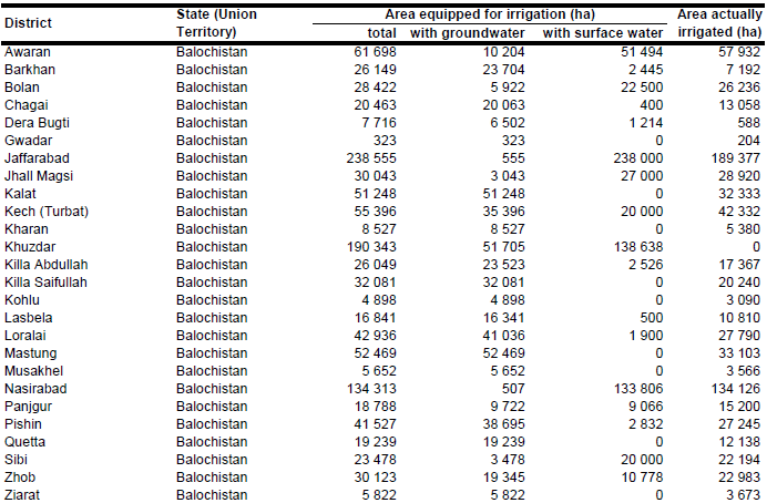
Balochistan
District data on irrigated areas and the source of irrigation water were derived from an inventory reporting the water sources of the irrigation areas in season 1994/95 [PK07]. AEI irrigated from wells and tube wells was scaled so that the total sum of these areas for whole Balochistan were similar to the statistics published by the Ministry of Agriculture for season 2004/05 [PK08]. Total AEI was increased that way by 180 854 ha to 1 173 099 ha, of which 490 000 ha were irrigated from groundwater and the remaining area from surface water (canals or spate irrigation).
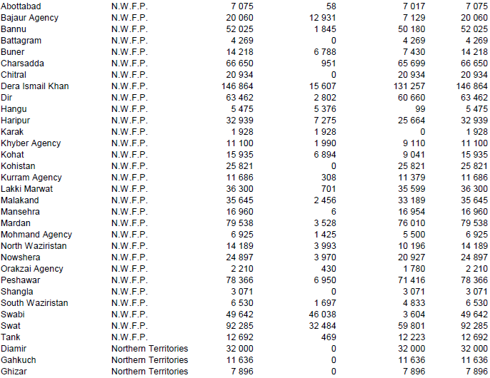
N.W.F.P. and F.A.T.A.
Irrigated area from canals, tanks, tube wells, wells, lift pumps and others were available at the district level for season 2006/2007 [PK09], [PK10]. It was assumed that areas irrigated from wells and tube wells represented areas irrigated with groundwater while areas irrigated from canals, tanks and lift pumps represented areas irrigated with surface water. Percentage irrigation from groundwater was computed by assuming that the contribution of groundwater in the group of others is similar to the contribution of groundwater when only considering the groundwater and surface water sources specified before. Total Area equipped for irrigation was 959 691 ha, of which 168 900 ha were irrigated with groundwater.
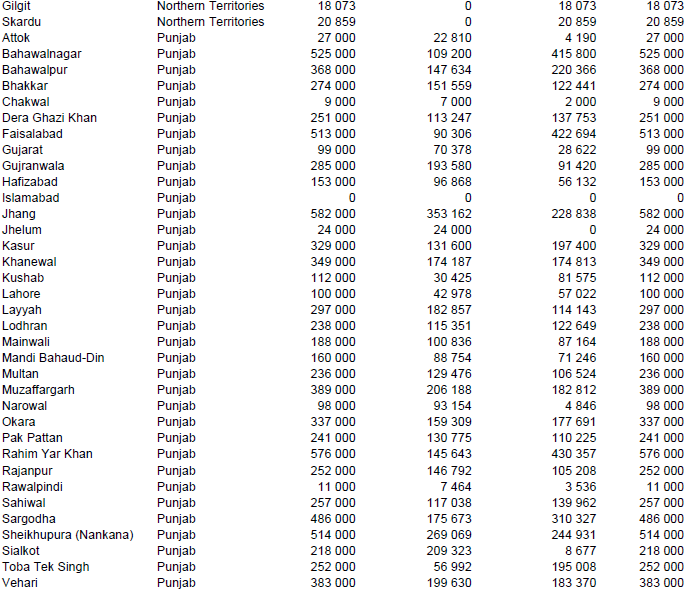
Punjab
According to the National Water Sector Profile [PK11] area equipped for irrigation in Punjab is 8.62 million ha, while the harvested area of irrigated crops is about 14 million ha per year indicating a high cropping intensity on irrigated land. More than half of the irrigated land is supplied by canal wells and canal tube wells meaning that there is conjunctive use of groundwater and surface water. Percentage irrigation from groundwater was computed at the district level by using data related to the season 2005/2006 [PK12]. Areas with conjunctive use were thus assumed to have 50 percent groundwater and 50 percent surface water supply. Furthermore we assumed that the fraction of area equipped for irrigation from groundwater is similar to the fraction of harvested irrigated crop area from groundwater. Area equipped for irrigation per district was estimated by subtracting the reported rainfed area from the reported net sown area in season 2005/2006 [PK13]. Area equipped for irrigation computed that way was 9 133 000 ha, of which 4 293 258 ha were irrigated with groundwater and 4 839 742 ha were irrigated with surface water.
Sindh
According to the National Water Sector Profile [PK11].Area equipped for irrigation in Sindh is 5.39 million ha. Area equipped for irrigation per district was estimated by subtracting the reported rainfed area in season 1997/1998 from the reported cultivated area [PK14]. Area equipped for irrigation computed that way was 5 369 589 ha. However, only small portions of this area are actually used, mainly because of the shortage of water supply from the Indus River System. In season 2004/2005 the net area sown was only 2.5 million ha in Sindh and the total harvested area was about 3.3 million ha [PK08]. Area actually irrigated was computed at the district level by using data on the area supplied by canals related to the season 2004/2005 [PK15] and data on the area supplied by wells, tube wells, canal wells and canal tube wells related to the season 1994/1995 [PK14]. Total AAI computed this way was 2 438 244 ha.
Northern Areas and AJ&K
Irrigated area per district, totals 90 464 ha. It was assumed that all the cultivated area as reported by the 1990 agricultural census [PK16] was irrigated. However, other studies indicate that the irrigated area in this very remote, mountainous region might be even larger than that reported by the census [PK17]. It was assumed that the whole AEI is irrigated with surface water.
References
[PK01]: FAO. 2013. AQUASTAT country profile of Pakistan, version 2011. FAO, Rome, Italy.
[PK02]: Agricultural Census Organization. 2012. Agricultural census 2010 - Pakistan report. Government of Pakistan, Statistics Division, http://www.pbs.gov.pk/node/484, 07/03/2010.
[PK03]: Ministry of Water and Power. 1994. Irrigation system of Pakistan. Islamabad, Chief Engineering Adviser’s Organisation.
[PK04]: Earth Satellite Corporation. 2004. Landsat GeoCover (2000/ETM+) Edition Mosaics, tiles 071-332, 071-333, 071-341, 071-342, 071-343, 071-344, 071-358, 071-359, 071-360 and 071-370. Sioux Falls, USA, USGS, http://glcfapp.umiacs.umd.edu:8080.
[PK05]: ESA. 2008. Regional Globcover Land Cover – Central Asia. Version 2.2. http://postel.mediasfrance.org/en/DOWNLOAD/, 24/03/2009.
[PK06]: POSTEL. 2008. GLOBCOVER landcover classification, Version 2.2, North Africa. Globcover database. http://toyo.mediasfrance.org/?GLOBCOVER, 24/03/2009.
[PK07]: Government of Balochistan. 2004. District database. Government of Balochistan, http://bdd.sdnpk.org, 27/07/2004.
[PK08]: MINFAL. 2006. Agricultural statistics of Pakistan 2004 – 2005. Government of Pakistan, Ministry of Food, Agriculture and Livestock (MINFAL), Economic Wing, Islamabad, Pakistan, http://faorap-apcas.org/pakistan/Agriculture Statistics of Pakistan 2004-05/ index.htm, 25/08/2009.
[PK09]: N.W.F.P. Bureau of Statistics. 2007. Development Statistics of N.W.F.P. 2007. Government of N.W.F.P., Planning and Development Department, Bureau of Statistics, Peshawar, Pakistan, http://www.nwfp.gov.pk/BOS/statsnwfp2005.htm, 25/08/2009.
[PK10]: N.W.F.P. Bureau of Statistics. 2007. Development Statistics of F.A.T.A. 2007. Government of N.W.F.P., Planning and Development Department, Bureau of Statistics, Peshawar, Pakistan, http://www.nwfp.gov.pk/BOS/statsfata05.htm, 25/08/2009.
[PK11]: Ministry of Water and Power. 2002. Pakistan water sector strategy. Vol. 5: National water sector profile. Ministry of Water and Power, Office of the Chief Engineering Advisor / Chairman Federal Flood Commission, http://www.waterinfo.net.pk/cwi.htm, 23/07/2008.
[PK12]: Punjab Bureau of Statistics. 2007. Punjab development statistics 2007. Government of the Punjab, Planning & Development Board, Bureau of Statistics, Lahore, Pakistan, http://www.pndpunjab.gov.pk/user\_files/File/punjab development Statistics 2007.pdf, 01/08/2009.
[PK13]: Punjab Bureau of Statistics. 2008. Punjab development statistics 2008. Government of the Punjab, Planning & Development Board, Bureau of Statistics, Lahore, Pakistan, http://www.pndpunjab.gov.pk/user\_files/File/PDS08.pdf, 01/08/2009.
[PK14]: Sindh Bureau of Statistics. 2002. Development statistics of Sindh. Government of Sindh, Bureau of Statistics, Karachi, Pakistan, http://sbos.sdnpk.org, 27/07/2004.
[PK15]: Agriculture Department. 2005. Final estimates of kharif crops 2004 and rabi crops 2004-05. Government of Sindh, Agriculture Department, Karachi, Pakistan, http://www.sindhagri.gov.pk/sitemap.html, 25/08/2009.
[PK16]: Agricultural Census Organization. 1992. Agricultural census 1990 - Pakistan report. Government of Pakistan, Statistics Division, Islamabad, Pakistan.
[PK17]: Ahmed, S. & Joyia, M.F. 2003. Northern Areas strategy for sustainable development. Background paper water, IUCN, Karachi, Pakistan, http://www.northernareas.org.pk, 27/07/2004.


