AQUASTAT - FAO's Global Information System on Water and Agriculture
Portugal
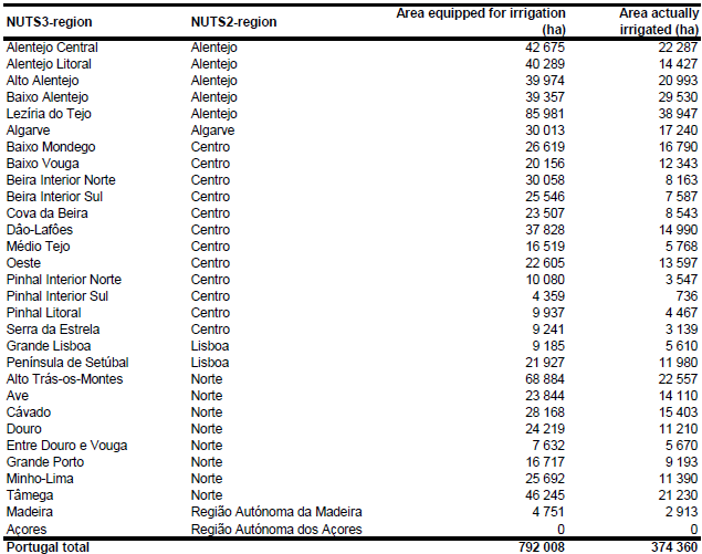
According to the data reported by EUROSTAT irrigated area in Portugal was decreasing during the last 15 years. While area equipped for irrigation was 877 690 ha in 1990, it decreased to 796 540 ha in 1995 and 791 990 ha in 2000. For the year 2003 the reported irrigable area was even much lower at 674 800 ha. The same trend was reported for the year actually irrigated, which was 631 120 ha in 1990 but only 248 040 ha in 2003 [PT01]. The agricultural census undertaken in 1999 reported an area equipped for irrigation of 792 008 ha and an area actually used for irrigation of 606 213 ha [PT02]. These census data were also used in this study because the area equipped for irrigation was reported down to 306 NUTS III units. The irrigated area by region is visible in the table below and the irrigated area both by region and by municipality can be downloaded as Portugal irrigation areas in PDF or Portugal irrigation areas in Excel (two sheets).
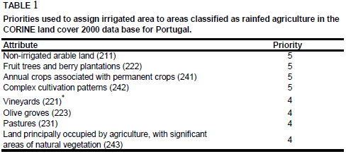
In order to distribute irrigated areas within the municipalities, irrigation areas were extracted from a digital land use map at the scale 1 : 250 000 [PT03] and from the Corine 2000 land cover database for Europe [PT04]. The large-scale irrigation areas shown on an irrigation map of the country [PT05] were represented very well that way. 421 805 ha irrigated areas were assigned in total to polygons extracted from the two digital data sets. The remaining irrigated area was assigned to polygons also extracted from the Corine 2000 land cover database for Europe [PT04] but classified as rainfed agriculture by using the priority levels shown in Table 1. Since the Corine 2000 database did not cover the island of Madeira, cultivated land was digitized from satellite imagery [PT06] and irrigated area was assigned to the digitized polygons.
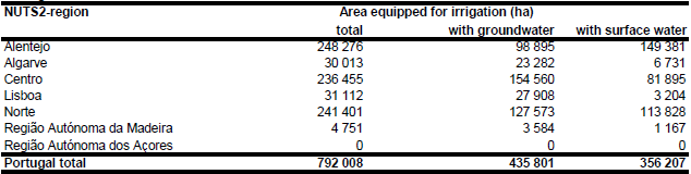
Area equipped for irrigation with groundwater was computed for 7 regions based on the data collected by the EU farm structure survey 2003 as described before.
References
[PT01]: Statistical Office of the European Communities (EUROSTAT). 2011. Irrigable and irrigated areas. http://epp.eurostat.ec.europa.eu/portal/ page/portal/agri_environmental_indicators/data/ database, 28/11/2011.
[PT02]: Instituto Nacional de Estatistica. 2003. Recenseamento Geral da Agricultura 1999. Principais Resultados por Região Agrária. http://www.ine.pt/prodserv/Rga/publicacaopdf\_ra.htm, 25/08/2005.
[PT03]: Instituto Geográfico Português. 2001. Carta de Ocupação de solo de 1990. http://www.igeo.pt/IGEO/portugues/Frameset-egeo.htm, 08/08/2005.
[PT04]: EEA. 2005. Corine land cover 2000 - vector by country (CLC2000), version 1. http://dataservice.eea.europa.eu/dataservice/metadetails.asp?id=667, 29/08/2005.
[PT05]: Freund, B. 1993. Entwicklung und Perspektiven der Bewässerungswirtschaft in Portugal. In H. Popp & K. Rother, eds. Die Bewässerungsgebiete im Mittelmeerraum, Passau, Germany, Passavia Universitätsverlag, 9-16.
[PT06]: Earth Satellite Corporation. 2004. Landsat GeoCover (2000/ETM+) Edition Mosaics, tile 071-170. Sioux Falls, USA, USGS, http://glcfapp.umiacs.umd.edu:8080.


