AQUASTAT - FAO's Global Information System on Water and Agriculture
Qatar
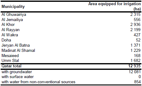
Area equipped for irrigation was 12 935 ha in 2001 [QT01]. The share of area equipped for irrigation per municipality was assumed to be similar to the share of total farmland reported in the Qatar Socio-Economic Atlas [QT02]. The irrigated area per municipality estimated that way is visible in the table below and also can be downloaded as Qatar irrigation areas in PDF or Qatar irrigation areas in Excel.
The outlines of the farms in Qatar were digitized from a land use map (map plate 84) published in the Qatar Socio-Economic Atlas [QT02] and irrigated area was assigned to these digitized polygones.
Area equipped for irrigation with groundwater is 93.4 percent of total area equipped for irrigation (12 081 ha), while the remaining area refers to irrigation with non-conventional water sources [QT01]. Area actually irrigated was 6 322 ha in year 2004 [QT01].
References
[QT01]: FAO. 2013. AQUASTAT country profile of Qatar, version 2008. FAO, Rome, Italy.
[QT02]: State of Qatar, Planning Council. 2001. Qatar socio-economic atlas. http://www.qsa.gov.qa/eng/GIS/ATLAS/english/default.htm, 20/01/2013.


