AQUASTAT - FAO's Global Information System on Water and Agriculture
Sierra Leone
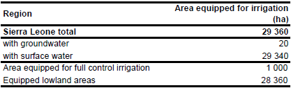
Area equipped for irrigation is 29 360 ha, of which 1 000 ha belong to full/partial control schemes and the remaining part to equipped wetlands [SL01]. The figures refer to year 1992. The irrigated area is visible in the table below and also can be downloaded as Sierra Leone irrigation areas in PDF or Sierra Leone irrigation areas in Excel. No sub-national information on areas equipped for irrigation was available.
The location of 14 irrigation projects was derived from the FAO irrigation map for Africa [SL02]. The related command area was given for 5 schemes and was summing up to 2 030 ha. The remaining irrigated area was assigned to cultivated land in mangroves or along the major rivers as digitized from satellite imagery [SL03].
The land in full/partial control schemes was used to grow sugar cane in year 1992 but most of the area in equipped lowlands was not operational [SL01]. Therefore, area actually irrigated was estimated at 10 000 ha based on this qualitative information. Based on the qualitative information contained in the AQUASTAT country reports [SL01] and groundwater use in neighbouring country Guinea, percentage of irrigation area from groundwater was set to 20 ha (2 percent of the area equipped for irrigation in full/partial control schemes).
References
[SL01]: FAO. 2005. AQUASTAT country profile Sierra Leone, FAO, Rome, Italy.
[SL02]: FAO. 1987 (updated in 2005). Irrigated areas in Africa. FAO, Rome, Italy.
[SL03]: Earth Satellite Corporation, 2004. Landsat GeoCover (2000/ETM+) Edition Mosaics, tiles 071-165, 071-166 and 071-177. Sioux Falls, USA, USGS (available at http://glcfapp.umiacs.umd.edu:8080/esdi/index.jsp).


