AQUASTAT - FAO's Global Information System on Water and Agriculture
Somalia
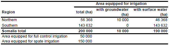
Before the outbreak of the civil war in 1991 area equipped for irrigation was 200 000 ha of which 50 000 ha AEI was full/partial control surface irrigation and 150 000 ha spate irrigation [SO01]. No sub-national statistical information on areas equipped for irrigation was available but full/partial control irrigation was mainly practised along the Juba and Shabelle rivers in the southern part of the country while in the dryer northern part of Somalia irrigation is practised as small-scale irrigation in dry riverbeds or adjacent areas, using water pumped from shallow wells and as spate irrigation. The irrigated area is visible in the table below and also can be downloaded as Somalia irrigation areas in PDF or Somalia irrigation areas in Excel.
Irrigated area was assigned to 15 irrigation projects according to their command area as reported by the FAO irrigation map for Africa [SO02]. The total command area of these schemes was 23 585 ha. Additionally, an irrigation area of 10 ha was assigned to 685 irrigation projects taken from an inventory of dams, drilled wells, dug wells and barrages [SO03]. The remaining irrigated area was assigned to all areas classified as irrigated by the AFRICOVER database [SO04]. These areas were grouped into three categories:
a) areas in which only irrigated crops are growing,
b) areas having a mixture of rainfed and irrigated crops with irrigated crops as main crop,
c) areas having a mixture of rainfed and irrigated crops with rainfed crops as main crop.
It was assumed, that the irrigation density in category b) is 67 percent of the density in category a) and that irrigation density in category c) is 33 percent of the density in category a).
The war has affected most of the full/partial control schemes in the south so that today hardly any scheme is fully operational [SO05]. In contrast most of the small-scale irrigation in the northern part is operational. To assign groundwater and surface water supplied irrigation areas, the country was split into a northern part and a southern part. Water supply is the southern part is from surface water [SO05]. 10 000 ha of groundwater irrigation representing extraction of irrigation water from springs and by wells was assigned to the northern part [SO06] and the remaining irrigation was assumed to be from surface water (representing spate irrigation areas). Areas actually irrigated were estimated at 20 000 ha for the northern region and 45 000 ha for the southern region.
References
[SO01]: FAO. 2005. AQUASTAT country profile Somalia, FAO, Rome, Italy.
[SO02]: FAO. 1987 (updated in 2005). Irrigated areas in Africa. FAO, Rome, Italy.
[SO03]: SWALIM. 2010. SWALIM GeoNetwork, http://geonetwork.faoswalim.org/geonetwork/srv/en/ main.home, 20/12/2010.
[SO04]: FAO. 2005. AFRICOVER, Somalia - Spatially Aggregated Multipurpose Landcover database. FAO, Rome, Italy, http://www.africover.org, 13/12/2004.
[SO05]: SWALIM. 2007. Status of medium to large irrigation schemes in Southern Somalia. Project Report W-05, Somalia Water and Land Information Management Project (SWALIM), Nairobi, Kenya, http://www.faoswalim.org/index.php, 27/08/2009.
[SO06]: SWALIM, 2007. Water Resources of Somalia. Project Report W-11, Somalia Water and Land Information Management Project (SWALIM), Nairobi, Kenya, http://www.faoswalim.org/index.php, 27/08/2009.


