AQUASTAT - FAO's Global Information System on Water and Agriculture
Chad
Area equipped for irrigation is reported to be 30 273 ha [TD01]. The figures refer to year 2002.
Irrigated area was distributed first to 6 large-scale schemes. The position and command area (in total 10 050 ha) of the schemes was taken from the FAO irrigation project database for Africa [TD02]. The remaining part of the irrigated area was assigned to zones of traditional or private irrigation and to palm groves as digitized from an irrigation map [TD03]. The outlines of the large scale schemes and of the digitized irrigation zones were adjusted using satellite imagery [TD04]. The irrigated area per region estimated that way is visible in the table below and also can be downloaded as Chad irrigation areas in PDF or Chad irrigation areas in Excel.
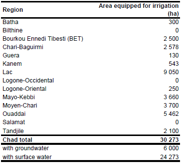
Area actually irrigated was 26 200 ha in year 2002. Area equipped for irrigation with groundwater was 6 000 ha (19.8 percent) in the same year [TD01].
References
[TD01]: FAO. 2005. AQUASTAT country profile Chad. FAO, Rome, Italy.
[TD02]: FAO. 1987 (updated in 2005). Irrigated areas in Africa. FAO, Rome, Italy.
[TD03]: UN Division for Sustainable Development. 2003. The integrated plan for Chad’s water development and management (SDEA). Chapter 1: Present situation of Chad’s water development and management, available at: http://www.un.org/esa/sustdev/tech\_coop/sdea/).
[TD04]: Earth Satellite Corporation. 2004. Landsat GeoCover (2000/ETM+) Edition Mosaics, tiles 071-228, 071-229, 071-230, 071-231, 071-240, 071-241, 071-242 and 071-243. Sioux Falls, USA, USGS (available at http://glcfapp.umiacs.umd.edu:8080).


