Noticias
En esta sección se presentan artículos y noticias sobre las actividades que lleva a cabo la FAO con apoyo de tecnología y métodos geoespaciales.

The recent availability of new satellite optical and radar Earth Observation missions, coupled with the development of Artificial Intelligence (AI) pattern recognition technologies and integrated in cloud-based platforms such as SEPAL and Google Earth Engine) have completely changed how we...
The Geospatial Unit organized the "Open House Day" to raise awareness and promote geospatial data and technology.
FAO has more than 30 years of experience in the development and use of geospatial data, methods and tools, which are applied...

With the increasing availability of multi-temporal and multi-sensor remote sensing imagery, mapping land features is less and less dependent on the existence of satellite information and more on the ability to access and use this data in a common environment....
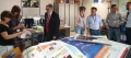
11-23 January 2019, FAO’s Senior Land Resource Information Management Expert, Gianluca Franceschini trained the ground-data collection team working under the Strengthening Agro-climatic Monitoring and Information System (SAMIS) project.
The team was made up of national consultants...
20 November 2018

Experts from South Sudan increased their awareness on the land cover database that FAO is preparing and discussed about classification systems adopted suitable for their country adoption thanks to a workshop organized by the FAO Geospatial team in Juba, South...