Actualités
Cette section présente des articles et des informations sur les activités réalisées par la FAO à l’aide de technologies et de méthodes géospatiales.

The Food and Agriculture Organization of the United Nations (FAO), the Regional Center for Agrometeorology, Hydrology and Meteorology (AGRHYMET), the Economic Community of West African States (ECOWAS ), the Sahara and Sahel Observatory (OSS) and SERVIR West Africa organized...
18 July 2022

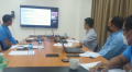
A technical training on using geospatial technologies, mapping and delineating intervention areas for the Forest and Farm Facility (FFF) in Nepal was organized on 18 July 2022. It aimed at strengthening forest and farm producer organizations (FFPOs) for monitoring...

On 1st July 2022, a consultation on identification of Nature Based Solutions (Nbs) and use of geospatial was organized by FAO, the International Council for Research in Agroforestry (ICRAF) in collaboration with Asian Institute of Technology at Departments of...
Field data collection training to analyze the spatio-temporal dynamics of air pollution and the delineation of hotspots in Lao PDR was organized from 17 to 19 May 2022 at the Institute of Research and Natural Resources and Environment Statistics, Ministry...
A new framework designed to monitor and report on the progress of restoration efforts throughout the duration of the UN Decade on Ecosystem Restoration has been launched by the Food and Agriculture Organization of the United Nations (FAO).
The Framework for...