Publications
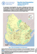
An assessment of land degradation was carried out following the UNCCD’s Good Practice Guidance (GPG) version 2 to monitor the baseline status (2000 - 2015) of the SDG Indicator 15.3.1 (Proportion of land that is...
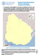
An assessment of land degradation was carried out following the UNCCD’s Good Practice Guidance (GPG) version 2 to monitor the baseline status (2000 - 2015) of the soil organic carbon sub-indicator of SDG Indicator 15.3.1...
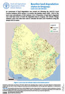
An assessment of land degradation was carried out following the UNCCD’s Good Practice Guidance (GPG) version 2 to monitor the baseline status (2000 - 2015) of the land cover sub-indicator of SDG Indicator 15.3.1 (Proportion...
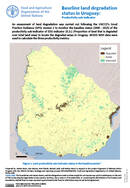
An assessment of land degradation was carried out following the UNCCD’s Good Practice Guidance (GPG) version 2 to monitor the baseline status (2000 - 2015) of the productivity sub-indicator of SDG Indicator 15.3.1 (Proportion of...
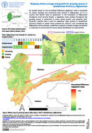
NDVI (Normalized Difference Vegetation Index) analysis is useful for wheat mapping and monitoring food security in Afghanistan, as it is a country that heavily relies on agriculture. In the framework of Afghanistan Emergency Food Security...