Assessment and mapping of the land degradation and sustainable land management bright and hotspots
Case study - Estimating ecosystems services at a territorial scale – Options for policy making, planning, and monitoring in the Kagera basin
Authors: Petri, M., Bunning, S.
Various land assessment options are available and suitable to be applied at a landscape scale for planning and management of natural resources and ecosystems so that climate smart agriculture (CSA) interventions can be fed in. The Transboundary Agro-ecosystem Management Project for the Kagera River Basin (Kagera TAMP), funded by GEF and implemented by FAO, has the goal to adopt an integrated ecosystems approach for the management of land resources in the basin (shared by Rwanda, Burundi, Uganda, and Tanzania). This is expected to generate local, national and global benefits including: restoration of degraded lands, carbon sequestration and climate change adaptation, agro-biodiversity conservation and sustainable use and improved agricultural production leading to increased food security and improved rural livelihoods and indirectly protect of international waters. In this framework, an assessment and mapping of the land degradation and sustainable land management bright and hotspots is under finalization and is being used to inform the project intervention strategy, identify best practices in the region, and guide effective and responsive Sustainable Land Management (SLM) intervention. The evaluation of SLM results is expected to advise policy making, planning and budgetary allocations, through supporting the analysis of major barriers to land resources conservation/management, and serving as baseline for future integrated landscape management approaches.
The appraisal is based on a method jointly developed by the Land Degradation Assessment in Drylands (LADA) project funded by GEF, through UNEP, to FAO, and WOCAT (World Overview of Conservation Approaches and Technologies) a global network and consortium of soil and water conservation specialists and institutions. In the Kagera basin, the assessment was realised at a national level in Burundi and Rwanda as the basin covers >60% of the country territory) and for the relevant parts of the Kagera basin in Tanzania and Uganda. The assessment allows a harmonized territorial estimation of the tangible component of the ecosystem’s good and services, including biomass, soil, water, biodiversity, and social and economic considerations. Results, built through the consensus among disparate group of experts, are a good example of multiple baseline information useful to transform interventions among sectors at landscape level so that multiple goals including those that address specific climate threats can be reached, and thereby and promoting CSA.
The method takes into consideration biophysical, social, economic, and ecological dimensions and uses relatively limited resources and can be conducted in a relatively short amount of time. For the basin which covers nearly 60.000 km2 the entire assessment has cost some 150.000 USD for the 4 countries including capacity development in the participatory expert assessment method with multiple sectors and quality control and validation and finalization of the database and maps. In this case 6 months were sufficient to complete a first draft set of resulting maps, while one year should be sufficient to complete the entire process.
A handover and ownership building process is now being initiated to transfer the results to selected governmental institutions, as to allow decision makers in the 4 countries to evaluate in each land use system/type (taking into consideration biophysical, socio-economical, and use of the land information and databases), what type of land degradation is actually happening, its status and trend, where it is happening and why, and with which ecological and socio-economical impacts. The analysis includes the degradation exacerbated by climate change and can depict variation in carbon storage in soil and biomass among others. At the same time, actual SLM technologies and approaches are assessed in terms of location/extent, effectiveness, and impacts. Relying on a strong, participatory and cross-sectoral national level effort, the method could be useful for long term monitoring of the impacts of SLM or territorial projects and interventions, to define areas with need for further intervention, and to identify best practices in use and deserving wider use. The method can be used for identifying and justifying catchment intervention and selection of the areas to be addressed in a wider landscape or basin. Information gathered will allow managing the wider landscape for multiple objectives, including sustainable productivity; resilience to climate variability and change; and climate change mitigation. Basing on available information, the various sector involved might built synergies among interventions and trade-offs that need to be addressed with all actors /stakeholders concerned in the territory.
Bibliography
Manual for the assessment of national level land degradation
DOWNLOAD the case study
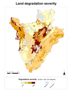
Map 1: Burundi: Comparing degradation and intervention effectiveness allows decision makers to depict hotspot areas requiring urgent interventions and identify good practices that can be scaled up or further SLM measures that are needed.
 1a. Degradation severity (extent, rate, and degree).
 1b. Effectiveness of implemented SLM technologies
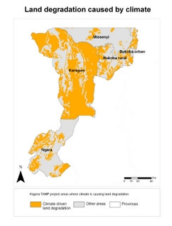
Map 2: Tanzania Kagera TAMP project area: Identification of areas where climate pressures are key causes of land degradation (incl. change in temperature, change of seasonal rainfall, extreme rainfall, floods and droughts.)


