

Key achievements
In Tanzania a training of extension staff and farmer animators in contour bund construction in Kirushya was conducted during the period. Five farmer animators and two extension staff were trained by the trained extension staff on construction and strengthening of contours. This was in response to the demand to reconstruct contours in a catchment where contouring was done poorly. The contoured part of the micro-catchment will be used to monitor sediment load as well since the fields are best positioned land management technologies up slope to directly influence water quality downstream.
- Increased savings from village savings and loan associations and income from harvests of crops planted on contours for their strengthening i.e. pineapple, pigeon peas, firewood and lemon grass. Increased banana production and unreliable markets are forcing farmers to process bananas to juice and beer that fetch even higher prices. Increased biomass of pastures through area closure and conservation is now being sold to herders and able farmers for mulching
- Continued honey harvesting of 120 litters honey ($ 800 value) from beehives in 3 catchments, established for forest degradation control
- Improved water availability of drying water sources through community integrated catchment management approaches i.e. effective management of all land use types in the catchment, thereby improving water infiltration and reducing runoff. This has saved time spent and distance covered by women and children to fetch water in 3 implementing catchments
- Increased awareness and management of farm lands through established Junior and Life Farmer Field Schools at selected Primary Schools. The pupils are also enjoying eating and selling fruits and bananas for nutrition improvement and income to the school.
Districts
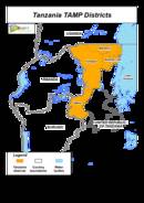
The project includes the four districts of Ngara, Karagwe, Bukoba and Missenye (recently divided from Bukoba) which are all part of the Kagera basin and are integrated administratively in the Kagera Region. These districts are spatially very large compared to the districts/provinces in Rwanda and Burundi.
Project implementing districts have increased to five after Karagwe district was subdivided into two i.e. Karagwe and Kyerwa districts. With this split the three implementing catchments were also subdivided one (Bujuruga) in Karawe and two (Kihanga/Katera and Murongo) in Kyerwa.
SLM specific activities

- Well established and managed banana field demonstrating combining technologies to reduce/control soil erosion, improve water holding capacity of the soil and improve soil fertility in Bujuruga, Karagwe district
In Tanzania the micro-catchments in Bukoba, Missenyi and Ngara districts finalized the establishment of the planned SLM-FFS, income generation, demonstration and community common interest initiated activities. Some of the planned SLM activities are still pending in Karagwe district because the district is yet to replace the service provider after Vi-Agroforestry discontinued with the services. There is also a considerable adoption of SLM technologies in almost all sights with about 15% of project implementing farmers having adopted. Both knowledge and skills as well as soil quality (fertility, water infiltration and holding capacity, organic matter content, soil organisms increase) are reported by farmers to be the key attributes for the realized increase in crop yield (banana, maize and beans production). There is quite some evidence of reduced soil erosion in the fields as a result of contouring, increased surface cover to about 90-95% and increased biomass in improved pasture FFS plots as well as improved pastures carrying capacity. The rate of success with these indicators varies from one micro-catchment to another.
Some additional SLM specific activities :
- Planned activities in Karagwe district were delayed by discontinuation of Vi-Agroforestry as the implementing service provider for for Kagera TAMP but were quickly picked by the replacing service provider “Kolping Society of Tanzania) in January 2014.
- More than 40 ha of improved pastures protected by constructing 4-5 meter wide firebreaks.
- 5 ha (1 ha in each selected catchment) of land established for improved pasture seed production and 40 ha pastures improved through reseeding with of Chloris gayana, Cenchrus ciliaris and Clitoria ternatea species.