Evapotranspiration measurement and remote sensing validation
Evapotranspiration (ET) is a component of the water cycle characterizing hydrological and ecological processes occurring between the land surface and the atmosphere.
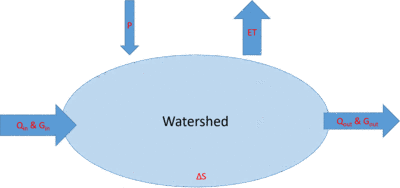
A simple hydrological balance, describing the flows of water in and out of a system, would be the most appropriate context to better illustrate the significance and value of evapotranspiration (ET).
A general water balance equation for, e.g., a watershed is:
P+Qin+Gin =Qout+Gout+ET+ΔS
Where:
P is precipitation
Qin is any surface water inflow coming from outside the basin. Usually this is very small for a watershed unless there is inter-basin water transfer
Gin is groundwater and sub-surface inflow coming from outside the basin
Qout is surface water running off the basin (as discharge, including rivers leaving the basin)
Gout is groundwater or sub-surface outflow going outside the basin
ET is evapotranspiration
ΔS is the change in storage (in reservoirs, soil and/or the bedrock and/or groundwater)
This equation uses the principles of conservation of mass, whereby any water entering a system must be equal to the sum of (i) the water leaving the system (either through evapotranspiration, surface runoff, or groundwater outflow) and (ii) the change in storage in the surface or the ground (as soil moisture, retained in bedrocks, or as groundwater).
A schematic view of a general basin water balance is drafted in the figure below.
Evapotranspiration (ET) implies a change of phase of water from liquid to gas (vapor) and is the sum of water that evaporates (E) from surfaces (bare soils and free water surfaces) and that transpire (T) from plants. ET represents the largest amount of water consumed by any system, particularly by agricultural cropping systems. The driving force for ET is the evaporative demand of the atmosphere (compounded through solar radiation, temperature, air humidity and wind) and in a typical summer day will induce a well-watered crop field to consume around 60 to 80 m3 of water per ha.
It must be understood that crops consume a large amounts of water (ET). In their life cycle, less than 1% of the water they abstract from the soil remains in the plant body, and the rest is transpirated to the atmosphere. Even though the amount of water in the plant body is relatively small compared to the ET, a small imbalance in the transport process (hardly detectable) that may occur in response to alterations in water supply or demand creates a plant water deficit. Very mild water deficits are often detrimental to yield. That is why irrigation becomes essential when the soil water stored from rainfall is insufficient to guarantee an optimal yield.
Furthermore, it must be appreciated that the seasonal evaporation losses from crop and soil surfaces are quite large relative to the amount of yield produced. It is not uncommon to require from 100 to more than 1000 m3 of water per kg of harvested crop yield. Therefore, high yields and high water consumption are unavoidably linked and, as a first approximation, dry matter production and ET of individual crops are positively related.
Box 1 – The process of plant transpiration (Fereres & Connor, 2004) Crop plants require a continuous supply of water to replace the water evaporated (transpired) from their aerial organs (mainly leaves). Such demand arises because the leaves are exposed to strong evaporative demand (strong fluxes of solar and thermal radiation and warm, dry air) while the internal plant surfaces are nearly saturated with water. For carbon dioxide (the substrate for photosynthesis) to enter the leaves, the microscopic leaf pores (stomata) must be open. But when the pores are open, water vapor freely escapes from the interior of the leaves. To sustain the water flow needed to prevent tissue dehydration, water flows from the soil into the root system and is transported via conductive xylem vessels to the leaves where it replaces the quota evaporated to the atmosphere. Thus, from a purely physical viewpoint, plants are water transport systems from a source, the soil, to a sink, the atmosphere. |
It is evident that knowing amounts and rates of ET leaving a systems (from crop fields to an entire basin) is fundamental for different purposes, including:
- Irrigation Management
- Yield prediction
- Assessment of crop water productivity
- Monitoring drought and crop stress
- Water Accounting
The major challenge, though, is that determining ET is an extremely difficult task.
There are different methods to determine crop ET in the field. Some of them are:
1) Eddy covariance/energy balance method
2) Bowen-ratio/energy balance method
3) Weighing lysimeters
4) Soil-moisture depletion method
5) Large Aperture Scintillometer
6) Penman-Monteith equation
These methods have their own specific advantages and limitations based on the theory behind and the instrumentation requirements. However, what they have in common is: (i) the restricted sampling area in the field (from 2-3 m2 to few hectares); (ii) the complexity and sophistication of the measurements so that they are mostly confined to scientific and research institutions having highly qualified personnel; (iii) substantial costs of purchase, maintenance and calibration; (iv) prohibitive when attempting to scale them up to larger areas (irrigation schemes, watershed, sub-national, national and basin scales).
The only feasible and affordable methods for ET determination on large scale are those performed through satellite Remote Sensing (RS). In fact, the progress and advances in space science of recent years have allowed to provide most relevant RS images publically available (at no cost) that can then be processed locally to derive ET and several other information. A few databases reporting directly ET values at different spatial (from 1000 to 100 m pixels’ size) and temporal (from monthly to daily time intervals) scales are also publically available.
There are several well-established RS-based algorithms for the determination of ET, including SEBAL (Surface Energy Balance Algorithm for Land), METRIC (Mapping Evapotranspiration at high Resolution with Internalized Calibration), SEBS (Surface Energy Balance System), GloDET (the Global Daily ET dataset provided by Water for Food, Daugherty Global Institute, Nebraska), OpenET (under preparation by Google with support of the World Bank), ETLook, ETMonitor, etc.
Unfortunately, also these methods have their own specific advantages and limitations and are all suffering from a generally limited and scattered field validation. Virtually, no validations are systematically carried out in the NENA Region.
To define the accuracy of RS ET data and identify if their uncertainty is acceptable for specific applications, a comparison with field ET measurements is essential. This comparison will not only serve to define the accuracy of RS ET data but also to provide the opportunity for calibrating the RS algorithms calculating ET.
FAO, through the Sida Project, the Water Scarcity Initiative (WSI), and in partnership with the International Center for Agricultural Research in Dry Area (ICARDA) and with the University of Cordoba (UCO), has recently initiated a network throughout the NENA Region to measure field Evapotranspiration (ET) of several crops over few seasons.
Countries involved at this initial stage of the Network establishment are Egypt, Jordan, Lebanon, Morocco and Tunisia. Crops under measurements are wheat, maize, sugar beet and pomegranate. Additional countries and crops will be included in the coming months.