FRA 2010 and 2015 Global Remote Sensing Surveys
While the FRA 1990 and 2000 remote sensing surveys of forest cover change only covered the pan-tropical region, the FRA 2010 remote sensing survey was the first comprehensive global survey on forest land use change dynamics over time, including deforestation, afforestation and the natural expansion of forests. The survey was implemented by FAO in collaboration with the EC Joint Research Centre and other partners.
The assessment used a sample-based approach, applying a systematic sampling design based on each longitude and latitude intersection with a reduced intensity above 60 degrees north due to the curvature of the Earth.
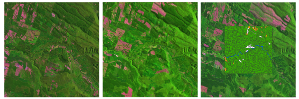
The sampling design covered the whole land surface of the Earth and consisted of about 13 500 samples, of which about 9000 did not contain deserts and areas with permanent ice. The area covered at each sample site is 10 km x 10 km, providing a sampling intensity of about 1 percent of the global land surface.
For each sample plot, Landsat images – dating from around 1990, 2000 and 2005 – were interpreted and classified using an automated supervised approach where national experts participated in the final validation. Nearly 7 million polygons were analyzed at each time interval to detect forest area, forest gains and forest losses 5 hectares or greater in size. A detailed description of the methodology applied in the FRA 2010 remote sensing survey was published in the journal, Remote Sensing, 2016 (8), and can be downloaded here. As part of FRA 2015, updated forest land-use and change rates (deforestation and afforestation) were calculated at global, regional (continent) and ecological zone scales for 1990, 2000 and 2010.
Key Outputs
- Global forest land-use change from 1990 to 2010: an update to a global remote sensing survey of forests
- The FRA 2010 Remote Sensing Survey: An outline of objectives, data, methods and approach
- Options and recommendations for a global remote sensing survey of forests. Global Forest Resources Assessment 2010