Events
From 28 March 2023 to 28 March 2023
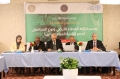
The steering committee for MerWat & IagWat projects was organised in Tunis on 28th March 2023. The project “Monitoring, evaluation and rationalization of water use for agriculture sector in Libya”(MerWat - OSRO/LIB/002/ITA) aims at supporting monitoring, evaluation, and rationalization of the agriculture...
From 28 March 2023 to 28 March 2023

The Geospatial unit is supporting the Assessment to verify land availability and accessibility for IDPs in the southern districts of Cabo Delgado and Nampula, Mozambique. A technical meeting with FAO partner organizations...
From 23 March 2023 to 23 March 2023
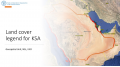
A technical meeting will be held on 23 March 2023 in Saudi Arabia. The objective of this meeting is to discuss the need of harmonized land cover representation system based on international standards i.e., 19144-2 using geospatial technologies and tools,...
From 22 March 2023 to 24 March 2023

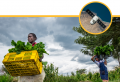
Water security has become a major issue in the 21st century due to various factors. Climate change has led to more extreme weather events, such as droughts and floods, disrupting water supplies and damaging infrastructure. Population growth and urbanisation have...
From 21 March 2023 to 23 March 2023
During the GEOGLAM capacity development (CapDev) workshop held in March 21-23, 2023, FAO Geospatial Unit (NSL) participated and contributed in delineating progresses, opportunities, priorities, and resources for the program. The workshop was useful to investigate possible collaboration and overlapping with...