Publications

Urbanization classes in the Agno river basin, Philippines (2020)
12 September 2023
12 September 2023
Urbanization data is essential in understanding livelihoods, food security, population characteristics and climatic sensitivity. Urbanization classes across the Agno river basin is obtained from the Global Human Settlement Layer (GHSL) to support the GEF-8 Clean...

An assessment of land degradation was carried out following the UNCCD’s Good Practice Guidance (GPG) version 2 for the SDG Indicator 15.3.1 (Proportion of land that is degraded over total land area) for Gedaref state...
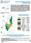
Land cover in the Agno river basin, Phillippines (2021)
11 September 2023
11 September 2023
Land cover data is vital in understanding livelihoods, food security and both exposure and sensitivity to climatic risks. It was obtained from the ESA Worldcover (2021) as a technical support to the GEF-8 Clean and...
Enhanced global land and water resources assessment for sustainable agriculture in a high-performing on-demand computing environment
11 September 2023
11 September 2023
FAO, in collaboration with the International Institute for Applied Systems Analysis (IIASA) and the Geomatics Unit of the Asian Institute of Technology (AIT) developeda free and open source tool to run Agro-Ecological Zoning (AEZ) at...
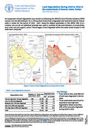
Land degradation during 2016 to 2022 in the watersheds of Sennar state, Sudan SDG Indicator 15.3.1
08 September 2023
08 September 2023
An assessment of land degradation was carried out following the UNCCD’s Good Practice Guidance (GPG) version 2 for the SDG Indicator 15.3.1 (Proportion of land that is degraded over total land area) for Sennar state...