Publications
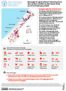
Damage to agricultural infrastructure due to the conflict in the Gaza Strip as of 20 May 2024
12 June 2024
12 June 2024
Utilising a baseline agricultural infrastructure layer and very high-resolution satellite imagery, FAO conducted an assessment of the number of agricultural infrastructures damaged in the Gaza Strip as a result of the recent conflict escalation. The...

Cultivated cropland area extent in Sudan Estimates for July 2023 in comparison to July average during 2018-2022
28 February 2024
28 February 2024
A rapid geospatial assessment was carried out to estimate the extent of cultivated cropland throughout Sudan for July 2023, compared to last 5-year (2018-2022) average by integrating data from satellite remote sensing, existing 2020 land...
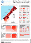
Overview of the damage to agricultural land and infrastructure due to the conflict in the Gaza Strip as of 15 February 2024
28 February 2024
28 February 2024
The ongoing conflict between Hamas and Israel erupted on October 7, 2023, leading to Israeli strikes on the Gaza Strip. Within two months, over 85 percent of Gaza's population was displaced, severely impacting agriculture. The...
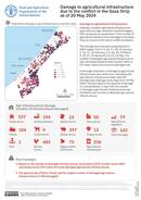
Damage to agricultural infrastructure due to the conflict in the Gaza Strip as of 15 February 2024
28 February 2024
28 February 2024
The damage to agricultural infrastructure was estimated using the available Sentinel 1 SAR images on January 04, 05, 16, 17, 28, 29, February 09, 10.
This is a proxy measure of damage estimatedby implementing the so-called coherence...
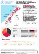
Damage to agricultural wells due to the conflict in the Gaza Strip as of 15 February 2024
28 February 2024
28 February 2024
Damage to agricultural wells The damage to agricultural wells was estimated using the available Sentinel 1 SAR images on January 04, 05, 16, 17, 28, 29, February 09, 10. This is a proxy measure of...