Publications
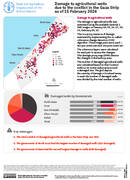
Damage to agricultural wells due to the conflict in the Gaza Strip as of 15 February 2024
28 February 2024
28 February 2024
Damage to agricultural wells The damage to agricultural wells was estimated using the available Sentinel 1 SAR images on January 04, 05, 16, 17, 28, 29, February 09, 10. This is a proxy measure of...

The damage to greenhouses was estimated using the available Sentinel 1 SAR images on January 04, 05, 16, 17, 28, 29, February 09, 10. This is a proxy measure of damage estimated by implementing the...
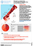
Sentinel data from January to February of 2020,2021, 2022, 2023 and September 2023 was used as a baseline for comparison with January-February 2024 for NDVI based change assessment. Significant change in cropland greenness was identified...
A rapid geospatial damage assessment of the 2023 conflict in the Gaza Strip on agricultural land and infrastructure
06 February 2024
06 February 2024
The ongoing conflict between Hamas and Israel erupted on 7 October 2023, leading to Israeli strikes on the Gaza Strip. Within two months, over 85 percent of Gaza's population was displaced, severely impacting agriculture. FAO...
Seasonal mapping of crop types and water use in Northern Gaza Strip: insights from remote sensing and field surveys (2021–2023)
06 February 2024
06 February 2024
This study focuses on assessing crop productivity and water use efficiency in the northern region of Gaza through remote sensing and field measurements. It aims to accurately map and identify crop types in the study...
