
Mapping in Burundi
Land use system

- Systèmes d'utilisation du sol du Burundi
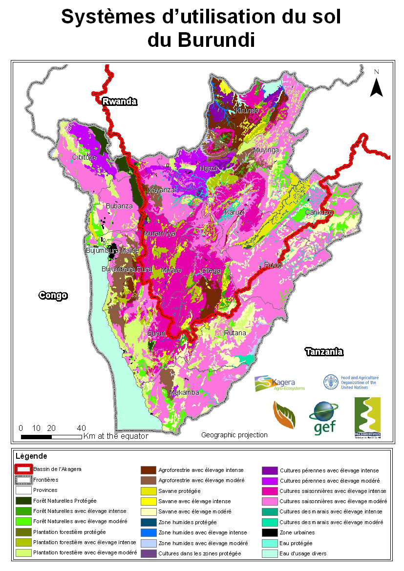
The use of land is the main driver of land degradation. After a planning and data collection phase in collaboration with the Nile Equatorial Lakes Subsidiary Action Program of the Nile Basin Initiative (NBI NELSAP), LUS workshops started in Gitega, Burundi from 8 to 16 November, 2010 with 8 participants experienced in GIS. Further to that, a validation phase was undertaken in 2011.
Land degradation and SLM mapping
This identification builds on baseline information regarding land degradation (LD) and sustainable land management (SLM) at a geographical scale and undertaken through the LADA-WOCAT Questionnaire for mapping. The LD and SLM maps are built using the land degradation assessment in drylands (LADA) method including two phases:
- the definition of the units of assessment by building the Land Use Systems (LUS) maps adapted for the use at the Kagera watershed scale and
- the use of the LADA WOCAT questionnaire for mapping (QM). The participatory assessment of LD and SLM was undertaken in Burundi in January 2011.

- Land degradation severity in Burundi (extent, rate and degree)


- Effectiveness of land management in Burundi

The LUS and QM maps were validated both through field visit conducted in 2012 by national and international experts and by comparison with other maps and satellite images. Also, experts participating at the QM participatory assessment were requested to analyze and assess map quality. A second workshop was organized in in March 2012 to validate both LUS and QM quality. Validated database was used to produce 80 maps including land degradation type, status, trend, extent, direct and indirect causes, impacts, and land use change. Also, the map included SLM analysis such as type of SLM in place, extent, effectiveness, and best practices.
LUS Map authors | |
|---|---|
NINDAMUTSA Astère | IGEBU |
RUFUGUTA Evariste | MINEEATU/CIE |
HAKIZIMANA Eliakim | DGE/DPPA |
RURANTIJE Aloys | IGEBU |
RUFUGUTA Evariste | MINEEATU/CIE |
HAKIZIMANA Eliakim | DGE/DPPA |
RURANTIJE Aloys | IGEBU |
NTUMIGOMBA Protais | IGEBU |
NDUWIMANA André | ABELO |
RWABITAGA Didace | IGEBU |
SYORI Aloys | IGEBU |
* All intellectual property rights, including copyright, in the work performed under the “Transboundary Agro-Ecosystem Management Programme for the Kagera River Basin” (thereafter referred as “Kagera TAMP”) shall be vested in FAO, including without any limitations, the right to use, publish, translate, sell or distribute, privately or publicly, any item or part thereof for non-commercial purposes. FAO hereby grants to the delegated institution(s) of beneficiary country a non-exclusive royalty-free license to use, publish, translate and distribute, privately or publicly, any item or part of the work performed under Kagera TAMP for non-commercial purposes. Delegated institutions and distribution entities in Burundi are: Centre Geomatique, IGEBU, DGFE, DGMAV, and Nile Basin Initiative.