Publications

Geospatial assessment of cultivated cropland extent in the Sudan
21 November 2023
21 November 2023
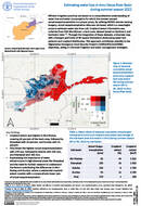
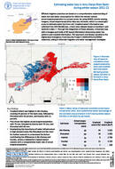
The Sudan, a vast Sahelian nation in northeastern Africa, heavily relies on its agriculture sector, supporting the livelihoods of 60–80 percent of its population. However, the recent armed conflict that began in mid-April 2023 has...

Cultivated cropland area extent in Sudan Estimates for August 2023 in comparison to August average during 2018-2022
17 November 2023
17 November 2023
A rapid geospatial assessment was carried out...
Efficient irrigation practices are based on acomprehensiveunderstanding of water lossand water consumption for which the remote–sensed actualevapotranspirationis aproper proxy.By utilizing MODIS remote sensing imagery, actual evapotranspiration data was retrieved, which is a meaningful proxy to...
Efficient irrigation practices are based on acomprehensiveunderstanding of water lossand water consumption for which the remote–sensed actualevapotranspirationis aproper proxy.By using MODIS remote sensing imagery, actual evapotranspiration data was retrieved, which is a meaningful proxy to...
Remote sensing determination of evapotranspiration
30 October 2023
30 October 2023
The Near East and North Africa (NENA) Region has long faced water scarcity due to natural causes. Still, factors like population growth, food security policies, and socioeconomic development have worsened the situation in recent decades....