
Spatial and spatio-temporal measures
At the interface between fisheries management and marine biodiversity conservation, spatial-based measures – namely zoning and area-time-gear type closures – are among the oldest forms of fisheries management. With the shift of fishery management towards the ecosystem approach to fisheries –a broader conception of ecosystem well-being – the use of spatial management tools is becoming more prevalent.
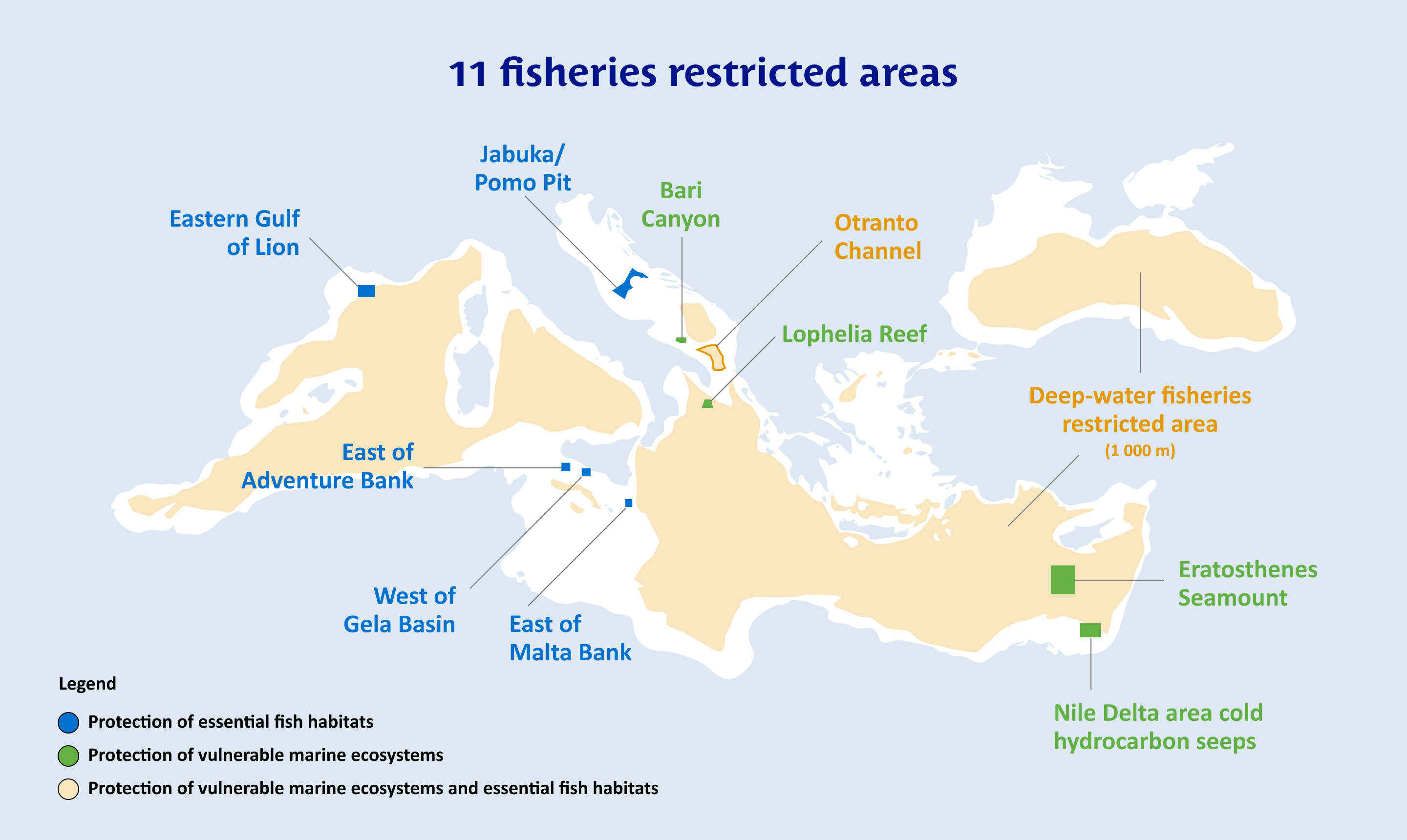
Under its ecosystem approach to fisheries, the GFCM has adopted spatial measures through fisheries restricted areas (FRAs). A FRA is a geographically defined area in which all or certain fishing activities are temporarily or permanently banned or restricted in order to improve the exploitation and conservation of harvested living aquatic resources or the protection of marine ecosystems (FAO, 2008).
In the GFCM context, a FRA is the area-based management tool used to protect marine ecosystems or sensitive habitats, such as vulnerable marine ecosystems (VMEs), from potentially significant adverse impacts (VME FRAs) and/or enhance the productivity of marine living resources (EFH FRAs), including in the deep sea. Essential fish habitats are defined as being essential to the ecological and biological requirements for critical life history stages of exploited fish species, and these areas may require special protection to improve the status of the stocks and long-term sustainability.
A FRA can potentially be established to protect any kind of marine resource and habitat (e.g. aggregations of vulnerable sponges, seamount areas, coralligenous formations, seagrass meadows, spawning grounds and reproduction sites for fish resources, etc.) from fishing activities.
The GFCM also adopts spatio-temporal measures to reduce fishing pressure in specific areas during particular periods/seasons (e.g. at spawning times or during migrations of vulnerable species). These measures are sometimes incorporated into GFCM multiannual management plans or taken into account in FRAs, and in a few cases they are used on a stand-alone basis.
GFCM Actions
- Establishment of spatial and spatio-temporal measures, including FRAs, to improve the status of key demersal species and/or the protection of vulnerable ecosystems. Mapping of essential fish habitats across the Mediterranean Sea, as emerging from the analysis of standardized surveys at sea, towards the identification of key areas to protect by means of FRAs in order to enhance the productivity of demersal fisheries.
- Mapping of FRAs established by GFCM countries within their national waters.
- Identification of VME indicators and EFHs, compiled in a regional database on sensitive benthic species and habitats to support scientific advice.
- Collection of information on VME indicator features, habitats and taxa through direct observations and the application of encounter and exploratory deep-sea bottom fishing reporting protocols.
- Mapping of fishing footprint through vessel monitoring system (VMS), automatic identification system (AIS), local ecological knowledge (LEK) and other tools.
Relevant Decisions
- Recommendation GFCM/47/2024/6 on the establishment of a fisheries restricted area in the Otranto Channel (geographical subarea 18), stemming from Recommendation GFCM/43/2019/5 and Resolution GFCM/44/2021/3
- Resolution GFCM/47/2024/2 on a roadmap for the implementation of a fisheries restricted area in the Cabliers coral mounds in the Alboran Sea, amending Resolution GFCM/46/2023/2
- Resolution GFCM/43/2019/6 on the establishment of a set of measures to protect vulnerable marine ecosystems formed by cnidarian (coral) communities in the Mediterranean Sea
- Resolution GFCM/41/2017/5 on a network of essential fish habitats in the GFCM area of application
Resources
- Appendix 17. Protocols for the protection of VMEs in the GFCM area of application | Report of the forty-second session
- International Guidelines for the Management of Deep-sea Fisheries in the High Seas
- Vulnerable Marine Ecosystems (VME) Database
- Vulnerable marine ecosystems: processes and practices in the high seas | Thompson, Sanders, Tandstad, Carocci & Fuller, 2016
- Fisheries management: marine protected areas and fisheries, p. 198 | FAO, 2011